IMAGES TAKEN NEAR TO
Station Road, NEWCASTLE, ST5 5AH
Introduction
This page details the photographs taken nearby to Station Road, ST5 5AH by members of the Geograph project.
The Geograph project started in 2005 with the aim of publishing, organising and preserving representative images for every square kilometre of Great Britain, Ireland and the Isle of Man.

There are currently over 7.5m images from over14,400 individuals and you can help contribute to the project by visiting https://www.geograph.org.uk
Image Map
Images are licensed for reuse under creativecommons.org/licenses/by-sa/2.0
Notes
- Clicking on the map will re-center to the selected point.
- The higher the marker number, the further away the image location is from the centre of the postcode.
Image Listing (11 Images Found)
Images are licensed for reuse under creativecommons.org/licenses/by-sa/2.0
Image
Details
Distance
1
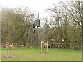
Sculpture, Keele
Where Station Road meets the bypass.
Image: © Richard Webb
Taken: 17 Mar 2022
0.08 miles
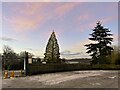
3

Keele Christmas Tree Farm
A popular local source of Christmas trees from late November onwards http://keelechristmastreefarm.co.uk
Image: © Jonathan Hutchins
Taken: 6 Dec 2014
0.10 miles
4
Trees at Keele Christmas Tree Farm
Image: © Jonathan Hutchins
Taken: 10 Dec 2022
0.10 miles
5
Keele Christmas Tree Farm
A popular local source of Christmas trees from late November onwards http://keelechristmastreefarm.co.uk
Image: © Jonathan Hutchins
Taken: 6 Dec 2014
0.12 miles

7
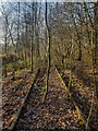
Disused Railway Lines between Silverdale Tunnel and Keele Station
The first part of the line to be built required the private Silverdale & Newcastle Railway, built in 1850 by ironmaster Ralph Sneyd, to become public. This was enabled by an Act of 1859 and passenger services from Stoke to Newcastle began in 1862. Silverdale was reached in May 1863.
Meanwhile, the Great Western Railway was planning to reach Manchester and in an effort to block this, the Market Drayton extension was completed in February 1870.
The last traffic on the line was coal from Apedale and Silverdale collieries, which ceased in December 1998 when the latter was closed.
https://en.wikipedia.org/wiki/Stoke_to_Market_Drayton_Line
Image: © Brian Deegan
Taken: 9 Dec 2019
0.18 miles
8
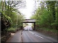
Railway Bridge, A525, Keele
The line is no longer in use
Image: © Geoff Pick
Taken: 25 Apr 2009
0.19 miles
9
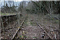
Keele Railway Station (Disused)
Keele railway station is a disused railway station in Staffordshire, England.
The Stoke to Market Drayton Line was opened by the North Staffordshire Railway (NSR) in 1870. The station, then called Keele Road was opened on the same day as the line opened. In 1898 the station was renamed Keele.
The line through the station was singled in 1934 and the number of platforms reduced to one but the line through the disused platform was retained as a passing loop for goods trains.
Passenger traffic at the station was withdrawn in 1956 and goods traffic was withdrawn in January 1967 when the station closed altogether. The line through the station remained in use until the closure of Silverdale Colliery in 1998.
https://en.wikipedia.org/wiki/Keele_railway_station
Image: © Brian Deegan
Taken: 24 Mar 2019
0.20 miles
10
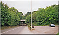
Site of former Keele station, 1999
View eastward on A525, under bridge carrying ex-North Stafford Stoke - Newcastle-under-Lyme (to left) - (to right) Market Drayton/Harecastle line. Keele station had been up to the right and was closed 7/5/56, when passenger services west of Silverdale ceased; Stoke - Silverdale 2/3/64 (goods 30/8/71), services on the branch to Harecastle having ended 27/4/31. Goods traffic to Harecastle (Alsager East Junction) lasted until 7/1/63, to Market Drayton until 16/3/67. The line over the bridge remains, buried in vegetation, having borne freight to/from Silverdale Colliery until 1998.(Cf. Image]).
Image: © Ben Brooksbank
Taken: 8 Sep 1999
0.21 miles