IMAGES TAKEN NEAR TO
Barracks Road, NEWCASTLE, ST55 9SZ
Introduction
This page details the photographs taken nearby to Barracks Road, ST55 9SZ by members of the Geograph project.
The Geograph project started in 2005 with the aim of publishing, organising and preserving representative images for every square kilometre of Great Britain, Ireland and the Isle of Man.

There are currently over 7.5m images from over14,400 individuals and you can help contribute to the project by visiting https://www.geograph.org.uk
Image Map
Images are licensed for reuse under creativecommons.org/licenses/by-sa/2.0
Notes
- Clicking on the map will re-center to the selected point.
- The higher the marker number, the further away the image location is from the centre of the postcode.
Image Listing (468 Images Found)
Images are licensed for reuse under creativecommons.org/licenses/by-sa/2.0
Image
Details
Distance
1
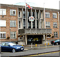
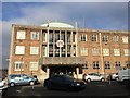
Entrance to the Civic Offices
The main entrance to Image
In 1910 nearby Stoke-on-Trent was formed by the amalgamation of six towns (Stoke-Upon-Trent, Hanley, Fenton, Longton, Burslem and Tunstall) but despite many efforts to include Newcastle they remained separate following an overwhelming vote of 97.4% opposing a merger. Following the Local Government Act 1972 it became the Borough of Newcastle-Under-Lyme.
Image: © Jonathan Kington
Taken: 21 Jun 2011
0.01 miles
2
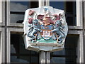
Newcastle-under-Lyme: coat of arms on the Civic Offices
Detail of the coat of arms above the main entrance of the Image
Image: © Chris Downer
Taken: 23 Jul 2011
0.01 miles
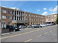
3
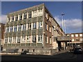
Civic Offices, Newcastle-under-Lyme
The building was opened in 1967, but its days are numbered, as the council offices are in the process of moving to Castle House, beside Queen's Gardens https://www.geograph.org.uk/photo/5688511
Image: © Jonathan Hutchins
Taken: 23 Feb 2018
0.01 miles
4
The Civic Offices
This building houses the offices for Newcastle-Under-Lyme town and borough councils.
In 1910 nearby Stoke-on-Trent was formed by the amalgamation of six towns (Stoke-Upon-Trent, Hanley, Fenton, Longton, Burslem and Tunstall) but despite many efforts to include Newcastle they remained separate following an overwhelming vote of 97.4% opposing a merger. Following the Local Government Act 1972 it became the Borough of Newcastle-Under-Lyme.
Image: © Jonathan Kington
Taken: 21 Jun 2011
0.01 miles
5
Newcastle-under-Lyme: Civic Offices on Merrial Street
Image: © Jonathan Hutchins
Taken: 7 Feb 2015
0.01 miles
6
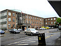
Newcastle-under-Lyme: Civic Offices
The headquarters of the town council, situated in Merrial Street.
Image: © Chris Downer
Taken: 23 Jul 2011
0.01 miles
7
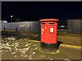
Postbox by night
On Merrial Street in Newcastle. Behind are the hoardings enclosing the site where the former council offices have been demolished and the site levelled.
Image: © Jonathan Hutchins
Taken: 18 Jan 2023
0.03 miles
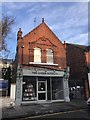
8
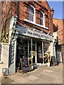
Gin and craft beer bar on Merrial Street
Before it became the premises of Ten Green Bottles, 46 Merrial Street can be seen vacant three years earlier at http://www.geograph.org.uk/photo/4345680
Image: © Jonathan Hutchins
Taken: 23 Feb 2018
0.03 miles
9
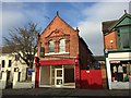
Newcastle-under-Lyme: 46 Merrial Street
A vacant shopfront on Merrial Street. The date above the first-floor windows is 1895.
Two years later the premises are home to Ten Green Bottles, a craft bar and bottle shop http://www.geograph.org.uk/photo/5272473
Image: © Jonathan Hutchins
Taken: 7 Feb 2015
0.04 miles
10
Newcastle-under-Lyme: 46 Merrial Street
The vacant business premises seen in http://www.geograph.org.uk/photo/4345680 are now home to Ten Green Bottles, a craft bar and bottle shop.
website: http://tengreenbottles.co
Image: © Jonathan Hutchins
Taken: 4 Feb 2017
0.04 miles