IMAGES TAKEN NEAR TO
Whitmore Road, NEWCASTLE, ST5 4DT
Introduction
This page details the photographs taken nearby to Whitmore Road, ST5 4DT by members of the Geograph project.
The Geograph project started in 2005 with the aim of publishing, organising and preserving representative images for every square kilometre of Great Britain, Ireland and the Isle of Man.

There are currently over 7.5m images from over14,400 individuals and you can help contribute to the project by visiting https://www.geograph.org.uk
Image Map
Images are licensed for reuse under creativecommons.org/licenses/by-sa/2.0
Notes
- Clicking on the map will re-center to the selected point.
- The higher the marker number, the further away the image location is from the centre of the postcode.
Image Listing (10 Images Found)
Images are licensed for reuse under creativecommons.org/licenses/by-sa/2.0
Image
Details
Distance
1
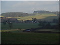
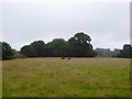
Green Fields near The Lymes
Looking down over some very "English" green fields over the A53 towards The Lymes farm from the road up to Shutlanehead. For anyone wishing to travel along the track from Shutlanehead to The Pleck, be warned that there's not really a track and it's pretty inaccessible at the best of times.
Image: © Iain McDonald
Taken: 21 Jan 2006
0.18 miles
2
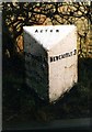
Old Milepost by the A53, Shutlane Head, Whitmore
Cast iron post by the A53, in parish of WHITMORE (NEWCASTLE UNDER LYME District), Shutlane Head, North of the A5182 junction; West of Butterton Church, on the verge in front of hedge, on East side of road. Lathe iron casting, erected by the County Council in the 19th/20th century.
Inscription reads:-
: WHITMORE 1¼ / ASHLEY 6 / MARKET - / DRAYTON 11 : : ACTON : : NEWCASTLE 3 :
Maker:-
: Chas. Lathe, Tipton. :
Grade II listed.
List Entry Number: 1027838 https://historicengland.org.uk/listing/the-list/list-entry/1027838
Milestone Society National ID: ST_MDNC11.
Image: © J Higgins
Taken: 1 Jan 2001
0.19 miles
5
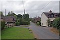
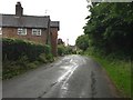
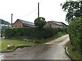
Butterton Near Keele
There are not much more than a dozen properties in this hamlet.
Image: © Glyn Baker
Taken: 21 Jul 2013
0.21 miles
7
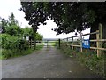
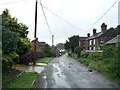
Butterton: entrance to lane to church
Image: © Jonathan Hutchins
Taken: 16 Jul 2016
0.24 miles
8
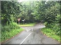
Rural crossroads at The Lymes on the A53
Looking from Butterton Lane across the A53 Whitmore Road to Lymes Road. The latter is a BOAT which eventually leads NW to Keele village.
Image: © Jonathan Hutchins
Taken: 16 Jul 2016
0.24 miles
10
Butterton: start of track and public footpath
Image: © Jonathan Hutchins
Taken: 16 Jul 2016
0.25 miles