IMAGES TAKEN NEAR TO
Eleanor Crescent, NEWCASTLE, ST5 3RF
Introduction
This page details the photographs taken nearby to Eleanor Crescent, ST5 3RF by members of the Geograph project.
The Geograph project started in 2005 with the aim of publishing, organising and preserving representative images for every square kilometre of Great Britain, Ireland and the Isle of Man.

There are currently over 7.5m images from over14,400 individuals and you can help contribute to the project by visiting https://www.geograph.org.uk
Image Map
Images are licensed for reuse under creativecommons.org/licenses/by-sa/2.0
Notes
- Clicking on the map will re-center to the selected point.
- The higher the marker number, the further away the image location is from the centre of the postcode.
Image Listing (36 Images Found)
Images are licensed for reuse under creativecommons.org/licenses/by-sa/2.0
Image
Details
Distance
1
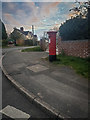
King George V Post Box, The Westlands
Post boxes in the United Kingdom bearing the Royal Cypher of King George V, who reigned for 26 years from 6 May 1910 to 20 January 1936.
Image: © Brian Deegan
Taken: 29 Mar 2020
0.05 miles
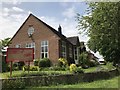
2
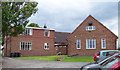
St Peter's Methodist Church, Westlands
To the rear of the church viewed from the car park.
Image
Image: © Carl Farnell
Taken: 22 Jun 2011
0.08 miles
3
St Peter's Methodist Church, Westlands
Looking from 'The Square' across to the church, which is situated at the top of Pilkington Avenue, Newcastle under Lyme, ST5 3RE
Image: © Carl Farnell
Taken: 22 Jun 2011
0.09 miles
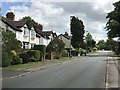
4
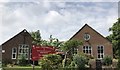
Methodist church and hall
St Peter's Methodist Church is on the left and the church hall on the right. A history of the two buildings can be found at http://www.northstaffordshiremethodists.org.uk/churches/church-profiles/st-peters-methodist-church.php
Image: © Jonathan Hutchins
Taken: 4 Jun 2018
0.09 miles
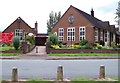
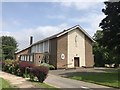
6
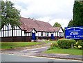
St. Andrew's Church hall, Westlands
The hall is adjacent to the main church building, (which is to the right) of the photo). Situated at the top of Pilkington Avenue, Newcastle under Lyme. ST5 3RE
Image
Image: © Carl Farnell
Taken: 22 Jun 2011
0.10 miles
7
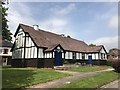
St Andrew's Church hall, Westlands
This was used for services before the new church https://www.geograph.org.uk/photo/5806972 was consecrated in 1962.
Image: © Jonathan Hutchins
Taken: 4 Jun 2018
0.10 miles
9
St Andrew's Church, Westlands
The church was consecrated in 1962.
Image: © Jonathan Hutchins
Taken: 4 Jun 2018
0.12 miles
10
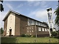
St Andrew's Church, Westlands
The church was consecrated in 1962.
Image: © Jonathan Hutchins
Taken: 4 Jun 2018
0.12 miles