IMAGES TAKEN NEAR TO
Greenside, NEWCASTLE, ST5 2SP
Introduction
This page details the photographs taken nearby to Greenside, ST5 2SP by members of the Geograph project.
The Geograph project started in 2005 with the aim of publishing, organising and preserving representative images for every square kilometre of Great Britain, Ireland and the Isle of Man.

There are currently over 7.5m images from over14,400 individuals and you can help contribute to the project by visiting https://www.geograph.org.uk
Image Map
Images are licensed for reuse under creativecommons.org/licenses/by-sa/2.0
Notes
- Clicking on the map will re-center to the selected point.
- The higher the marker number, the further away the image location is from the centre of the postcode.
Image Listing (263 Images Found)
Images are licensed for reuse under creativecommons.org/licenses/by-sa/2.0
Image
Details
Distance
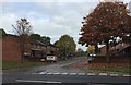
1
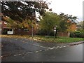
Newcastle-under-Lyme: Fletcher Bank from Dunkirk
Image: © Jonathan Hutchins
Taken: 29 Oct 2015
0.03 miles
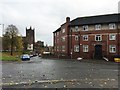
2
Newcastle-under-Lyme: Sutton House
A building divided into flats.
Image: © Jonathan Hutchins
Taken: 13 Aug 2016
0.04 miles
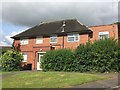
3
Newcastle-under-Lyme: Ashfields Grange
A sheltered housing scheme off Knutton Lane/Hall Street.
Image: © Jonathan Hutchins
Taken: 11 Jul 2015
0.04 miles
4
Newcastle-under-Lyme: Bailey Street
Over the wall at the top end of this short cul-de-sac is Sainsbury's superstore and car park.
Image: © Jonathan Hutchins
Taken: 29 Oct 2015
0.05 miles
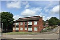
5
Newcastle-under-Lyme: The Holborn, Castle Hill Road
As the sign over the door indicates, The Holborn was once the base of operations for the Newcastle Area Office of Staffordshire County Council's Social Services Department. In the mid-2000s this relocated to the Borough Council's Civic Offices, and since then the building is more or less a three-storey suite of junk rooms, though various proposals have been put forward for its use. The road leading down past the building towards St Giles' Church is also called Holborn: this is now rudely truncated by the A34 dual carriageway.
Image: © Jonathan Hutchins
Taken: 29 Oct 2015
0.06 miles
6
Newcastle-under-Lyme: Bridge Street Subway (1)
Image: © Jonathan Hutchins
Taken: 11 Jul 2015
0.06 miles
7
Newcastle-under-Lyme: Bridge Street Subway (2)
Image: © Jonathan Hutchins
Taken: 11 Jul 2015
0.06 miles
8
Newcastle-under-Lyme: Bridge Street Subway (3)
Image: © Jonathan Hutchins
Taken: 11 Jul 2015
0.06 miles
9
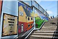
Newcastle-under-Lyme: Bridge Street Subway (4)
Image: © Jonathan Hutchins
Taken: 11 Jul 2015
0.06 miles
10

Newcastle-under-Lyme: Bridge Street Subway (5)
Image: © Jonathan Hutchins
Taken: 11 Jul 2015
0.06 miles