IMAGES TAKEN NEAR TO
Enderley Street, NEWCASTLE, ST5 2DE
Introduction
This page details the photographs taken nearby to Enderley Street, ST5 2DE by members of the Geograph project.
The Geograph project started in 2005 with the aim of publishing, organising and preserving representative images for every square kilometre of Great Britain, Ireland and the Isle of Man.

There are currently over 7.5m images from over14,400 individuals and you can help contribute to the project by visiting https://www.geograph.org.uk
Image Map
Images are licensed for reuse under creativecommons.org/licenses/by-sa/2.0
Notes
- Clicking on the map will re-center to the selected point.
- The higher the marker number, the further away the image location is from the centre of the postcode.
Image Listing (208 Images Found)
Images are licensed for reuse under creativecommons.org/licenses/by-sa/2.0
Image
Details
Distance
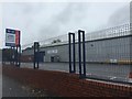
1
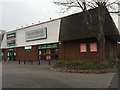
Newcastle-under-Lyme: commercial units on Enderley Street
Image: © Jonathan Hutchins
Taken: 23 Nov 2015
0.02 miles
2
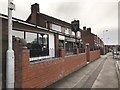
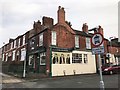
Newcastle-under-Lyme: The Freebird
Named after the Lynyrd Skynyrd song, the Freebird is a real ale and live music pub.
Image: © Jonathan Hutchins
Taken: 12 Mar 2017
0.04 miles
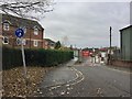
3
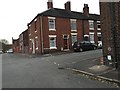
Newcastle-under-Lyme: junction of Wilson Street and Shaw Street
Image: © Jonathan Hutchins
Taken: 23 Nov 2015
0.04 miles
4
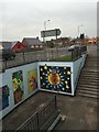
Newcastle-under-Lyme: subway on the A34
Image: © Jonathan Hutchins
Taken: 23 Nov 2015
0.05 miles
5
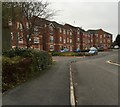
Newcastle-under-Lyme: The Mill
New housing development off Enderley Street.
Image: © Jonathan Hutchins
Taken: 23 Nov 2015
0.05 miles
6
Newcastle-under-Lyme: The Albert
The Albert Inn, standing on the corner of Liverpool Road and Brindley Street, opened as a beer house in 1861.
Image: © Jonathan Hutchins
Taken: 12 Mar 2017
0.06 miles
7
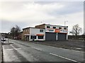
Newcastle-under-Lyme: Mr Tyre
This was a North Staffs Tyre and Battery autocentre till acquired by Mr Tyre Ltd in June 2014 and subsequently rebranded.
Image: © Jonathan Hutchins
Taken: 12 Mar 2017
0.06 miles
8
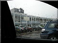
Newcastle Under Lyme College in the rain
This is the main entrance of Newcastle Under Lyme College, on Liverpool Road. In the autumn of this year (2009) the whole college is leaving this slightly tired old building and moving to brand spanking new, state of the art premises nearby. Don't expect it will make much difference to the weather though! A supermarket chain has bought this site and will building their own "state of the art" premises, no doubt .....
Image: © Mari Buckley
Taken: 1 Jul 2009
0.07 miles
9
Newcastle-under-Lyme: closed bus depot
First Bus announced in June 2015 its proposal to close this comparatively small depot, partly because of its proximity to their Stoke Adderley Green depot. Closure took place on 5th September 2015.
Image: © Jonathan Hutchins
Taken: 24 Oct 2015
0.08 miles
10
Newcastle-under-Lyme: Brampton Sidings
This is the dead-end of Brampton Sidings, but a path continues on to meet the A34. It is also a National Cycle Route. This is more or less the route of the long-gone Newcastle-Market Drayton railway line, as the road's name 'Sidings' suggests.
Image: © Jonathan Hutchins
Taken: 20 Nov 2016
0.08 miles