IMAGES TAKEN NEAR TO
Ryebank Crescent, NEWCASTLE, ST5 2BN
Introduction
This page details the photographs taken nearby to Ryebank Crescent, ST5 2BN by members of the Geograph project.
The Geograph project started in 2005 with the aim of publishing, organising and preserving representative images for every square kilometre of Great Britain, Ireland and the Isle of Man.

There are currently over 7.5m images from over14,400 individuals and you can help contribute to the project by visiting https://www.geograph.org.uk
Image Map
Images are licensed for reuse under creativecommons.org/licenses/by-sa/2.0
Notes
- Clicking on the map will re-center to the selected point.
- The higher the marker number, the further away the image location is from the centre of the postcode.
Image Listing (281 Images Found)
Images are licensed for reuse under creativecommons.org/licenses/by-sa/2.0
Image
Details
Distance
1
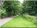
Station Walks, Newcastle-Under-Lyme
Formerly known as Brampton Walks, this path alongside grass and trees is close to the line of the disused North Staffordshire Railway around the north edge of Newcastle.
Image: © Derek Harper
Taken: 30 Jun 2006
0.01 miles
2
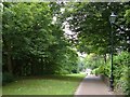
Station Walks, Newcastle-Under-Lyme
A view looking in the opposite direction to Image In the distance, in Image, the path reaches Hempstalls Lane.
Image: © Derek Harper
Taken: 30 Jun 2006
0.01 miles
3
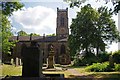
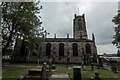
St Georges Church
The Churchyard is tranquil green space in the Centre of Newcastle Under Lyme
Image: © Glyn Baker
Taken: 19 Jul 2013
0.03 miles
4
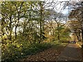
Autumn tints on Station Walks
Former trackbed of the Newcastle-Market Drayton line.
Image: © Jonathan Hutchins
Taken: 24 Nov 2021
0.03 miles
5
St. George's Church, Newcastle Under Lyme
Church. 1828. By Francis Bedford, built as a Commissioners Church, and designated as Parish Church in 1856. Coursed and squared rubble facing to brick structure. West tower, nave with 2 aisles under a single span, chancel. Narrow tower is enclosed by aisles, with only the polygonal angle buttresses projecting from the west wall. 3 prinicpal stages, with 4-centred arched doorway and long 2-light window over, and paired bell chamber lights. Embattled parapet and crocketed angle pinnacles. Aisles to north and south articulated into 6 bays divided by buttresses capped with crocketed pinnacles between eaves parapet. 2-light Late Decorated style windows, and blind arcading in west walls. North porch a later addition with heavy parapet and buttresses. Blocked south door now a window. Chancel partly a later addition with 5-light east window with foiled circle. Iron entrance gates and railings in eastern tooled sandstone retaining wall. INTERIOR: a single space, scarcely divided by slender clustered shafts to 4-bay arcade, supporting rib vaulting over nave and aisles. Western gallery with arcade of 3 principal and 2 narrow arches carried on blind arches below. Chancel has boarded roof with single ornate truss with pendants. Scalloped arch carried on short corbelled piers to later chancel extension, stone faced on interior. Chancel chapels to north and south, with organ to north and traceried screen separating south chapel. Floors throughout have encaustic tiles, possibly by Minton. Oak pews, reredos and panelling. Stained glass: east window has the Ascension flanked by figures of Saints George, Michael, Luke and John. North aisle windows 1861-1892 in similar styles, though by different artists, with figures on traceried grounds, and a Rennaissance style window of 1929. South aisle windows 1895-1910, with figures against a traceried and landscaped ground. (Newcastle Under Lyme 1173-1973: N.Staffs Polytechnic: 1973-; Briggs John: St.George's Newcastle Under Lyme, 1828-1978: N.Staffs Polytechnic: 1978-; The Buildings of England: Pevsner N: Staffordshire: Harmondsworth).
https://historicengland.org.uk/listing/the-list/list-entry/1219946
Image: © Brian Deegan
Taken: 24 Sep 2017
0.04 miles
6
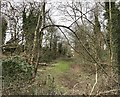
Newcastle-under-Lyme: Station Walks
The route of the former Newcastle to Market Drayton railway, viewed here from the parapet on Queen Street.
Image: © Jonathan Hutchins
Taken: 12 Mar 2017
0.04 miles
7
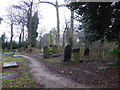
Newcastle-under-Lyme: St George's churchyard
Image: © Jonathan Hutchins
Taken: 11 Feb 2017
0.04 miles
8
Newcastle-under-Lyme: St George's Church car park
Image: © Jonathan Hutchins
Taken: 11 Feb 2017
0.04 miles
9
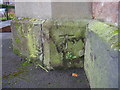
Benchmark on St George's Church
This benchmark was established in 1844 during the First primary levelling of England & Wales, and was levelled with a height of 457.9480 feet [139.5826 metres] above mean sea level (Liverpool datum). It was included as a side level on the Manchester to Gloucester levelling line. The surveyor's description was "No. 168(b). New Church, Newcastle-under-Lyme. Bolt in South side of tower ; 1.20 ft. above surface" (Public Abstract p.27).
Image: © Shantavira
Taken: 29 Nov 2014
0.04 miles
10
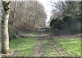
Route of former railway between Hempstalls Lane & Queen Street
Part of the old railway line just east of Brampton Sidings - "Station Walks" just off image to the left follows the route
Image: © Rob Jones
Taken: 6 Mar 2015
0.05 miles