IMAGES TAKEN NEAR TO
Liverpool Road, NEWCASTLE, ST5 2AT
Introduction
This page details the photographs taken nearby to Liverpool Road, ST5 2AT by members of the Geograph project.
The Geograph project started in 2005 with the aim of publishing, organising and preserving representative images for every square kilometre of Great Britain, Ireland and the Isle of Man.

There are currently over 7.5m images from over14,400 individuals and you can help contribute to the project by visiting https://www.geograph.org.uk
Image Map
Images are licensed for reuse under creativecommons.org/licenses/by-sa/2.0
Notes
- Clicking on the map will re-center to the selected point.
- The higher the marker number, the further away the image location is from the centre of the postcode.
Image Listing (441 Images Found)
Images are licensed for reuse under creativecommons.org/licenses/by-sa/2.0
Image
Details
Distance
1
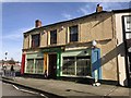
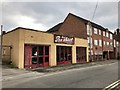
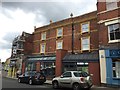
Newcastle-under-Lyme: Jollies
Jollies at 6-8 Liverpool Road is an arts and crafts materials shop and also offers workshop and studio space for hire.
Website: http://www.jollies-arts.co.uk
Image: © Jonathan Hutchins
Taken: 4 Mar 2017
0.00 miles
2
Newcastle-under-Lyme: Jollies
Jollies at 6-8 Liverpool Road is an arts and crafts materials shop and also offers workshop and studio space for hire. This is the side view on Corporation Street. The Liverpool Road frontage can be seen in http://www.geograph.org.uk/photo/5300795
Image: © Jonathan Hutchins
Taken: 12 Mar 2017
0.01 miles
3
Newcastle-under-Lyme: Hickman Street
Image: © Jonathan Hutchins
Taken: 11 Jul 2015
0.01 miles
4
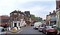
Liverpool Road, Newcastle-Under-Lyme
The junction with Bridge Street (left). The gabled building with the timber-effect facade is the Full Moon pub.
Image: © Derek Harper
Taken: 30 Jun 2006
0.02 miles
5
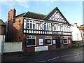
Newcastle-under-Lyme: The Full Moon
On the wall beneath the roof and gable end is a frieze listing the previous names of the pub:
1836 Royal Scotch Grey 1868 Gardeners Arms 1985 Coachhouse 1992 Newcastle Alehouse 1994 Holy Inadequate 1999 The Full Moon
Image: © Jonathan Hutchins
Taken: 4 Feb 2017
0.02 miles
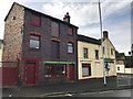
6
Newcastle-under-Lyme: Stan Pimlott garage
The Stan Pimlott garage, 14-16 Hickman Street was built about 1960 and is still owned by the Pimlott family.
Image: © Jonathan Hutchins
Taken: 12 Mar 2017
0.02 miles
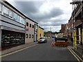
7
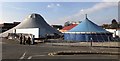
Circus in central Newcastle
NoFit State Circus is a contemporary circus company. Here in April 2018 they will premiere 'Lexicon' "- a daring, seductive and utterly contemporary take on circus for a seated audience in the round."
Newcastle-under-Lyme is the birthplace of the famous equestrian and cavalryman, Philip Astley, who in 1768 created the circus ring and invented the modern circus form. Just across the dual carriageway from this site, subway art commemorates him: see https://www.geograph.org.uk/photo/5311710 and https://www.geograph.org.uk/photo/5311688
Image: © Jonathan Hutchins
Taken: 23 Feb 2018
0.02 miles
8
Newcastle-under-Lyme, ale house
Bridge Street Ale House, on Bridge Street; micro-pub with single room at front, and small sitting room behind, and casks in the former shop window. Four cask ales and four draught ciders were on offer at my visit. http://www.bridgestreetalehouse.co.uk/
Image: © Mike Faherty
Taken: 3 Aug 2015
0.02 miles
9
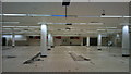
Derelict former Sainsbury's store in Newcastle-under-Lyme
The interior of the former Sainsbury's, taken in November 2010. The site is currently (August 2014) cleared and awaiting development.
Image: © Jonathan Hutchins
Taken: 27 Nov 2010
0.02 miles
10
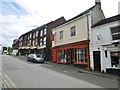
Newcastle-under-Lyme: 5-9 High Street
Image: © Jonathan Hutchins
Taken: 11 Jul 2015
0.03 miles