IMAGES TAKEN NEAR TO
Elliott Street, NEWCASTLE, ST5 1JL
Introduction
This page details the photographs taken nearby to Elliott Street, ST5 1JL by members of the Geograph project.
The Geograph project started in 2005 with the aim of publishing, organising and preserving representative images for every square kilometre of Great Britain, Ireland and the Isle of Man.

There are currently over 7.5m images from over14,400 individuals and you can help contribute to the project by visiting https://www.geograph.org.uk
Image Map
Images are licensed for reuse under creativecommons.org/licenses/by-sa/2.0
Notes
- Clicking on the map will re-center to the selected point.
- The higher the marker number, the further away the image location is from the centre of the postcode.
Image Listing (117 Images Found)
Images are licensed for reuse under creativecommons.org/licenses/by-sa/2.0
Image
Details
Distance
1
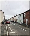
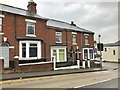
Elliott Street, Newcastle-under-Lyme
Image: © Jonathan Hutchins
Taken: 18 Feb 2018
0.01 miles
2
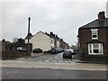
Newcastle-under-Lyme: junction of King Street and Elliott Street
Image: © Jonathan Hutchins
Taken: 11 Feb 2017
0.03 miles
3
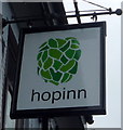
Sign for the Hopinn public house, Newcastle-under-Lyme
Image: © JThomas
Taken: 11 Jun 2016
0.04 miles
4
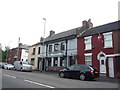
The Hopinn public house, Newcastle-under-Lyme
On Albert Street.
Image: © JThomas
Taken: 11 Jun 2016
0.05 miles
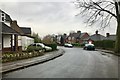
5
Newcastle-under-Lyme: Clifton Terrace
Image: © Jonathan Hutchins
Taken: 11 Feb 2017
0.05 miles
6

Osteopathic clinic, Newcastle-under-Lyme
Image: © Jonathan Hutchins
Taken: 18 Feb 2018
0.05 miles
7
Stoke-on-Trent: Kingsfield Oval, Basford
Image: © Jonathan Hutchins
Taken: 11 Feb 2017
0.05 miles
8
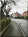
Stoke-on-Trent: Kingsfield Oval, Basford
Image: © Jonathan Hutchins
Taken: 11 Feb 2017
0.06 miles
9
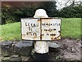
Newcastle-under-Lyme: 19th-century milepost
A good example of a C19 milepost, illustrating the standardisation of roads and the introduction of turnpikes to facilitate the transport needs of the increasingly industrial landscape of C19 Staffordshire. This cast iron milepost is set in its original location, and is intact.
The milepost is Grade II listed.
Image: © Jonathan Hutchins
Taken: 11 Feb 2017
0.06 miles
10
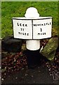
Old Milepost by the A53 Etruria Road, near The Polite Vicar, Basford
Cast iron post by the A53, in parish of NEWCASTLE UNDER LYME (NEWCASTLE UNDER LYME District), near New Vic Hotel, Basford, South West of "The Polite Vicar" PH, in tarmac path against retaining wall, on North side of road. Hales iron casting erected by the Newcastle under Lyme & Leek turnpike trust in the 19th century.
Inscription reads:-
: LEEK / 11 / MILES : : NEWCASTLE / 1 / MILE :
Maker:-
: HALES / COBRIDGE :
Grade II listed. List Entry Number: 1392367
https://historicengland.org.uk/listing/the-list/list-entry/1392367
Milestone Society National ID: ST_LKNC11.
Image: © J Higgins
Taken: 1 Jan 2000
0.06 miles