IMAGES TAKEN NEAR TO
Well Street, NEWCASTLE, ST5 1BP
Introduction
This page details the photographs taken nearby to Well Street, ST5 1BP by members of the Geograph project.
The Geograph project started in 2005 with the aim of publishing, organising and preserving representative images for every square kilometre of Great Britain, Ireland and the Isle of Man.

There are currently over 7.5m images from over14,400 individuals and you can help contribute to the project by visiting https://www.geograph.org.uk
Image Map (Loading...)


Getting Data...Please wait
Leaflet Map data © OpenStreetMap
Images are licensed for reuse under creativecommons.org/licenses/by-sa/2.0
Notes
- Clicking on the map will re-center to the selected point.
- The higher the marker number, the further away the image location is from the centre of the postcode.
Image Listing (329 Images Found)
Images are licensed for reuse under creativecommons.org/licenses/by-sa/2.0
Image
Details
Distance
1
Newcastle-under-Lyme: corner of Well Street and Garden Street
Image: © Jonathan Hutchins
Taken: 4 Mar 2015
0.01 miles
2
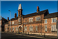
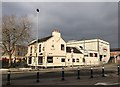
The Barracks, Newcastle Under Lyme
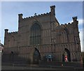
The Italian styled Militia Barracks were built in 1855 from red brick. The Barracks were the headquarters of the 3rd King's Own Staffordshire Rifle Regiment, which assembled annually at Newcastle for training, until 1880. In 1882 W.H. Dalton bought the Barracks and settled them in trust for use by the Rifle Volunteers of Newcastle, which became the Territorial Force in 1907.
No23 Neville Malkin's "Grand Tour" of the Potteries
This building could quite easily be mistaken for some fortress in an early movie or even the prototype for a kiddies' fort, but, in fact, it is the Italian-style Barracks in Newcastle, built in 1855.
More info >> http://www.thepotteries.org/tour/022.htm
Image: © Brian Deegan
Taken: 2 May 2020
0.03 miles
3
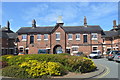
Inside the Barracks Workshops
Former Militia Barracks used as a drill station by the Staffordshire Yeomanry and base for G Company, 5th Battalion North Staffs Regiment in 1914.
Image: © John M
Taken: 16 Apr 2014
0.04 miles
4
The Barracks Workshops
Former Militia Barracks used as a drill station by the Staffordshire Yeomanry and base for G Company, 5th Battalion North Staffs Regiment in 1914.
Image: © John M
Taken: 16 Apr 2014
0.04 miles
5
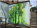
Newcastle-under-Lyme: subway mural
This fine evocation of the town's best-known landmark the Guildhall (see e.g. http://www.geograph.org.uk/photo/2101219 ) is on the wall of the steps out of Grosvenor Gardens roundabout. To the left one ascends to the High Street, to the right the steps give on to Stubbs Street/Barracks Road.
Transcription of artists' details in lower right:
Painted by Joe, Jake,
Jack, Josh, Mart, Tam,
Giuseppe, & Anthony,
2005
Image: © Jonathan Hutchins
Taken: 29 Jun 2015
0.04 miles
6

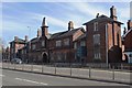
Newcastle Under Lyme old Fire Brigade Headquarters
Newcastle Under Lyme old Fire Brigade Headquarters, Barrack Road, Newcastle Under Lyme, Staffordshire
Image: © Kevin Hale
Taken: 29 Jul 2010
0.04 miles
7
Pasta di Piazza, Newcastle-under-Lyme
On the corner of Stubbs Street, facing the Grosvenor Gardens roundabout. Barracks Road is the dual carriageway in the foreground. On the right the large red letters denote the back of Brassingtons, a bar now closed.
Image: © Jonathan Hutchins
Taken: 21 Feb 2018
0.05 miles
8
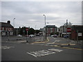
Service road off Barracks Road, Newcastle under Lyme
The service road provides access to premises off Barracks Road (part of Newcastle's inner ring road); the road between the two is an access road to the bus station, which is behind the photographer.
Image: © Richard Vince
Taken: 29 Jun 2013
0.05 miles
9
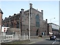
Holy Trinity Catholic Church - Newcastle-under-Lyme
Image: © Anthony Parkes
Taken: 11 Apr 2014
0.05 miles
10
Holy Trinity Roman Catholic Church, Newcastle-under-Lyme
Image: © Jonathan Hutchins
Taken: 2 Dec 2014
0.05 miles