IMAGES TAKEN NEAR TO
Highfield Avenue, NEWCASTLE, ST5 0JP
Introduction
This page details the photographs taken nearby to Highfield Avenue, ST5 0JP by members of the Geograph project.
The Geograph project started in 2005 with the aim of publishing, organising and preserving representative images for every square kilometre of Great Britain, Ireland and the Isle of Man.

There are currently over 7.5m images from over14,400 individuals and you can help contribute to the project by visiting https://www.geograph.org.uk
Image Map (Loading...)


Getting Data...Please wait
Leaflet Map data © OpenStreetMap
Images are licensed for reuse under creativecommons.org/licenses/by-sa/2.0
Notes
- Clicking on the map will re-center to the selected point.
- The higher the marker number, the further away the image location is from the centre of the postcode.
Image Listing (44 Images Found)
Images are licensed for reuse under creativecommons.org/licenses/by-sa/2.0
Image
Details
Distance
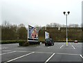
1
Wolstanton Retail Park: car park and perimeter road
Image: © Jonathan Hutchins
Taken: 8 Oct 2016
0.06 miles
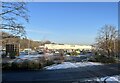
2
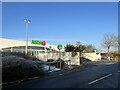
Wolstanton Retail Park: Asda car park
Image: © Jonathan Hutchins
Taken: 21 Dec 2015
0.07 miles
5
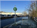
Information board at Wolstanton Retail Park
A close-up of the board is seen in https://www.geograph.org.uk/photo/7387904
Image: © Jonathan Hutchins
Taken: 21 Jan 2023
0.12 miles
6
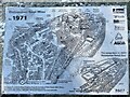
Information board at Wolstanton Retail Park (detail)
Shows a detailed reconstruction of the mining complex, now entirely gone and replaced by a retail park.
The board is shown in context at https://www.geograph.org.uk/photo/7387895
Image: © Jonathan Hutchins
Taken: 21 Jan 2023
0.13 miles
7
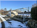
Un-sheltered seating at Wolstanton Bowls Club
With just one panel remaining out of four there would be barely any protection from the elements.
Image: © Jonathan Hutchins
Taken: 21 Jan 2023
0.13 miles