IMAGES TAKEN NEAR TO
Peacock Walk, NEWCASTLE, ST5 0GL
Introduction
This page details the photographs taken nearby to Peacock Walk, ST5 0GL by members of the Geograph project.
The Geograph project started in 2005 with the aim of publishing, organising and preserving representative images for every square kilometre of Great Britain, Ireland and the Isle of Man.

There are currently over 7.5m images from over14,400 individuals and you can help contribute to the project by visiting https://www.geograph.org.uk
Image Map (Loading...)


Getting Data...Please wait
Leaflet Map data © OpenStreetMap
Images are licensed for reuse under creativecommons.org/licenses/by-sa/2.0
Notes
- Clicking on the map will re-center to the selected point.
- The higher the marker number, the further away the image location is from the centre of the postcode.
Image Listing (35 Images Found)
Images are licensed for reuse under creativecommons.org/licenses/by-sa/2.0
Image
Details
Distance
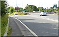
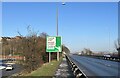
1
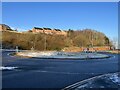
Roundabout between Wolstanton and the A500
Image: © Jonathan Hutchins
Taken: 21 Jan 2023
0.09 miles
2
Roundabout between Wolstanton and the A500
Image: © Jonathan Hutchins
Taken: 21 Jan 2023
0.09 miles
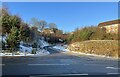
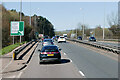
3
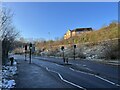
Pedestrian crossing on the A527
This is the former access road to the former colliery, now occupied by Wolstanton Retail Park. The A527 rises from its junction with the A500 up to Wolstanton and then turns south into the centre of Newcastle.
Image: © Jonathan Hutchins
Taken: 21 Jan 2023
0.10 miles
4
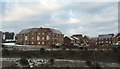
New housing development at Wolstanton
This new estate lies above the A500 and a new access road to the A527, and is here viewed from the car park of Wolstanton Retail Park on the opposite side of the access road. The banners proclaim the development is by Bloor Homes https://bloorhomes.com , who have named it 'Wulfstan Grange'; Wolstanton means 'Wulfstan's Town'. It is built on the site of the former sports field of Wolstanton Colliery; the colliery site itself is now home to the Retail Park.
Image: © Jonathan Hutchins
Taken: 30 Dec 2014
0.11 miles
5
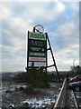
Sign for Wolstanton Retail Park
The usual list of corporate occupants of a Retail Park is here enhanced by being displayed against a (presumably replica) colliery's headgear, recalling the fact that the site was formerly occupied by Wolstanton Colliery.
Image: © Jonathan Hutchins
Taken: 30 Dec 2014
0.12 miles
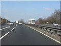
6
Slip road along the A500 in Wolstanton
Image: © Mat Fascione
Taken: 11 Jul 2015
0.13 miles
7
A500 at the exit for Wolstanton Retail Park
A "dumbbell" junction inserted on this section of the A500 many years after its 1974 opening.
Image: © Peter Whatley
Taken: 24 Mar 2011
0.13 miles
8
Access road to new housing estate off A527
Image: © Jonathan Hutchins
Taken: 21 Jan 2023
0.14 miles
9
Fork sign on the A500 below Wolstanton
Image: © Jonathan Hutchins
Taken: 21 Jan 2023
0.14 miles
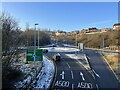
10
Queensway (A500) at Wolstanton Junction
Image: © David Dixon
Taken: 7 Apr 2023
0.14 miles