IMAGES TAKEN NEAR TO
Jonathan Road, STOKE-ON-TRENT, ST4 8LP
Introduction
This page details the photographs taken nearby to Jonathan Road, ST4 8LP by members of the Geograph project.
The Geograph project started in 2005 with the aim of publishing, organising and preserving representative images for every square kilometre of Great Britain, Ireland and the Isle of Man.

There are currently over 7.5m images from over14,400 individuals and you can help contribute to the project by visiting https://www.geograph.org.uk
Image Map
Images are licensed for reuse under creativecommons.org/licenses/by-sa/2.0
Notes
- Clicking on the map will re-center to the selected point.
- The higher the marker number, the further away the image location is from the centre of the postcode.
Image Listing (73 Images Found)
Images are licensed for reuse under creativecommons.org/licenses/by-sa/2.0
Image
Details
Distance
1
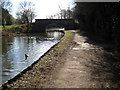
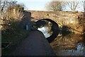
Trent and Mersey bridge 105
An old farm bridge now used as a footpath/cyclepath only.
Image: © Peter Fleming
Taken: 4 Mar 2010
0.08 miles
2
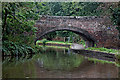
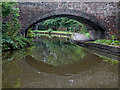
Limekiln Bridge south of Trentham in Stoke-on-Trent
This is the Trent and Mersey Canal, looking south towards Limekiln Bridge, No 105. The bridge was originally just an accommodation bridge linking fields south of Newpark Farm, but housing has now spread across both sides of the canal, and the bridge now carries a public footpath.
Image: © Roger Kidd
Taken: 16 Sep 2019
0.09 miles
3
Limekiln Bridge south of Trentham in Stoke-on-Trent
This is the Trent and Mersey Canal, looking south towards Limekiln Bridge, No 105. The bridge was originally just an accommodation bridge linking farmer's fields, but housing has now spread across both sides of the canal, and the bridge now carries a public footpath.
Image: © Roger Kidd
Taken: 16 Sep 2019
0.09 miles
4
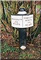
Old milemarker north of Limekiln Bridge, Stoke on Trent
Milemarker by the Trent & Mersey Canal, in parish of Stoke on Trent (Stoke on Trent District), North of Limekiln Bridge No 105, West side of the canal.
Inscription reads:-
: SHARDLOW / 52 / MILES : : PRESTON / BROOK / 40 / MILES :
Maker:-
: R&D / STONE / 1819 :
Grade II listed.
List Entry Number: 1260225 https://historicengland.org.uk/listing/the-list/list-entry/1260225
Surveyed
Milestone Society National ID: TMC-52
Image: © Milestone Society
Taken: Unknown
0.09 miles
5
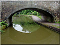
Limekiln Bridge south of Trentham in Stoke-on-Trent
This is the Trent and Mersey Canal, looking south through the arch of Limekiln Bridge, No 105. The bridge was originally just an accommodation bridge linking fields south of Newpark Farm, but housing has now spread across both sides of the canal, and the bridge now carries a public footpath.
Image: © Roger Kidd
Taken: 16 Sep 2019
0.09 miles
6
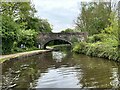
Trent and Mersey Canal south of Trentham, Stoke-on-Trent
Looking through the arch of Lime Kiln Bridge, No 105. This carried a farm track until the surrounding housing was built, and has been replaced for road traffic by another bridge (104A) fifty metres to the south-east.
Image]
Image: © Roger D Kidd
Taken: 30 May 2011
0.09 miles
7
Bridge 105 on the Trent and Mersey Canal
Near Trentham.
Image: © Andrew Abbott
Taken: 6 May 2024
0.09 miles

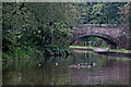
10

Canal north of Barlaston in Staffordshire
This is the Trent and Mersey Canal, looking south towards Limekiln Bridge, No 105.
Image: © Roger Kidd
Taken: 16 Sep 2019
0.09 miles