IMAGES TAKEN NEAR TO
Honeywall, STOKE-ON-TRENT, ST4 7HZ
Introduction
This page details the photographs taken nearby to Honeywall, ST4 7HZ by members of the Geograph project.
The Geograph project started in 2005 with the aim of publishing, organising and preserving representative images for every square kilometre of Great Britain, Ireland and the Isle of Man.

There are currently over 7.5m images from over14,400 individuals and you can help contribute to the project by visiting https://www.geograph.org.uk
Image Map
Images are licensed for reuse under creativecommons.org/licenses/by-sa/2.0
Notes
- Clicking on the map will re-center to the selected point.
- The higher the marker number, the further away the image location is from the centre of the postcode.
Image Listing (50 Images Found)
Images are licensed for reuse under creativecommons.org/licenses/by-sa/2.0
Image
Details
Distance
1
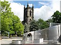
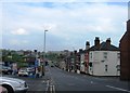
Stoke church viewed from near the town hall.
The trees help to contrast the old and the new.
Image: © www fotodiscs4u co uk
Taken: 6 Jun 2006
0.02 miles
2
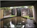
Stoke Bottom Lock
This is the lowest lock of a flight of five on the Trent and Mersey Canal in Stoke. I believe it was rebuilt here in the 1960s when the original line of the canal was moved to accommodate the new road system in the city. This lock has been fabricated out of concrete as opposed to the original which would have been made out of brick/stone.
Image: © Andy Beecroft
Taken: 10 Aug 2004
0.09 miles
3
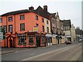
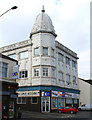
Talbot Hotel - Stoke
Talbot Hotel is at the bottom of Trade Street, Church Street runs along the frontage.
"A popular working-class activity, especially during the Wakes, was the game of 'prison bars'. It was played between two adult teams of eleven by the music of a flute or tin whistle and drum. The game entailed venturing from a den, and capturing opponents who would be taken into a 'prison' and held there until rescued by one of their team mates. It was not for the faint-hearted, and injuries were commonplace.
It was played on fete days on the field - known as Prison Bar Meadow - attached to Norton Hall Farm, whilst a field behind Wedgwood's Etruria Works had been given in perpetuity to locals and that was christened Prison Bars Field.
The Staffordshire Advertiser of August 10th 1850 records that during Stoke Wakes, prison-bar matches took place throughout the week on the race-course at Boothen. The men of Stoke parish beat those from Burslem parish, and all convened afterwards at the Talbot Inn, where the winners received half a sovereign each, and the losers a silk handkerchief each. There were also contests between factory teams from Stoke, Burslem, Hanley and Longton."
Image: © Steven Birks
Taken: 11 Feb 2006
0.12 miles
4
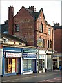
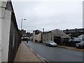
Stoke-upon-Trent: Floyd Street / Hall Street
This street bears two street name signs one above another high on the wall of the building on the left. The older states 'Hall Street', the newer 'Floyd Street'.
Image: © Jonathan Hutchins
Taken: 10 Dec 2015
0.13 miles

7
Dome on Liverpool Road, Stoke
Stone- or tile-faced building with a decorative dome on Liverpool Road. Visible in a 1932 postcard of the street (http://www.thepotteries.org/postcards/stoke/5.htm )
Image: © Espresso Addict
Taken: 7 Apr 2007
0.14 miles
8
Advert at bottom of Hartshill Road, Stoke
Shops on Hartshill Road - the junction with Geen Street just visible at the right.
Advert reads: Hercules The modern cycle
Image: © Steven Birks
Taken: Unknown
0.14 miles
9
Courtyard at the former Spode works
This photograph shows a small part of the scene depicted in Image The gate visible in that picture was locked shut and this photo was taken through a gap in its railings.
Image: © Russ Willey
Taken: 22 Feb 2022
0.14 miles
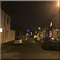
10
Looking south-west along Elenora Street
Image: © Basher Eyre
Taken: 2 May 2016
0.14 miles