IMAGES TAKEN NEAR TO
Westland Street, STOKE-ON-TRENT, ST4 7HD
Introduction
This page details the photographs taken nearby to Westland Street, ST4 7HD by members of the Geograph project.
The Geograph project started in 2005 with the aim of publishing, organising and preserving representative images for every square kilometre of Great Britain, Ireland and the Isle of Man.

There are currently over 7.5m images from over14,400 individuals and you can help contribute to the project by visiting https://www.geograph.org.uk
Image Map
Images are licensed for reuse under creativecommons.org/licenses/by-sa/2.0
Notes
- Clicking on the map will re-center to the selected point.
- The higher the marker number, the further away the image location is from the centre of the postcode.
Image Listing (11 Images Found)
Images are licensed for reuse under creativecommons.org/licenses/by-sa/2.0
Image
Details
Distance

3
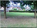
Site of the Domesday Village of Pinchetel, Penkhull
The stone reads :-
This stone marks the entrance to the former
Iron Age Fort and the Domesday Village
of
Pinchetel
a Royal Manor from 1086
to the time of Edward II
The hill-top village of Penkhull was probably the earliest inhabited place within the area now known as the Potteries, being settled by the Celts, Romans and Anglo-Saxons in turn. It was ideally situated by reason of its wooded hunting grounds, its clear views over the surrounding countryside and its closeness to the streams in the Lyme Valley on the western, and the Trent Valley on the eastern side.
The village may have been protected by a primitive hill-fort, although no remains of such a construction have been discovered. In 1086, the Domesday Book described the Manor of Penkhull (which it called "Pinchetel") as a village of great size, with over 1,000 acres of arable land stretched out over parts of present-day Newcastle-under-Lyme, Hanley, Shelton, Stoke and Boothen.
However, soon after this survey was taken, Penkhull began to decline in importance with the building of a New Castle nearby. A market town quickly grew up within sight of this castle and by the year 1173, the Borough of Newcastle-under-Lyme ("New Castle under the Elm Trees") had been established. This borough was to remain the largest centre of population and leading market town in the area for the next 600 years until the rise of the six towns now called Stoke-on-Trent.
Domesday Listed as :-
PENKHULL. Earl Algar held it. 2 hides, with its dependencies.
Land for 11 ploughs. In lordship 2;
17 villagers and 6 smallholders with 8 ploughs.
Meadow, 2 acres; woodland 1 league long and 2 furlongs wide. Value £6.
Image: © Brian Deegan
Taken: 12 Jul 2020
0.14 miles
4
The Mount, Penkhull
The west front and main entrance to The Mount, a mansion built by Josiah Spode II. The house was built on the site of an old farmhouse between Penkhull and Hartshill around 1803-04 and is now a grade I listed building. Later the site of the North Staffordshire School for the Blind and Deaf (from 1897), it became the Willows Primary School in 2003.
Neville Malkin's "Grand Tour" of the Potteries No.16
http://www.thepotteries.org/tour/016.htm
Image: © Brian Deegan
Taken: 28 May 2021
0.17 miles
5
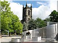
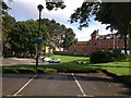
Stoke church viewed from near the town hall.
The trees help to contrast the old and the new.
Image: © www fotodiscs4u co uk
Taken: 6 Jun 2006
0.17 miles

7
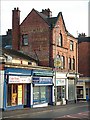
Advert at bottom of Hartshill Road, Stoke
Shops on Hartshill Road - the junction with Geen Street just visible at the right.
Advert reads: Hercules The modern cycle
Image: © Steven Birks
Taken: Unknown
0.23 miles
8
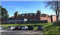
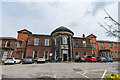
North Staffordshire Royal Infirmary
The Infirmary saw its last patients in 2012, though the site has not yet (May 2015) been fully vacated by the hospital Trust.
Image: © Jonathan Hutchins
Taken: 22 Apr 2015
0.23 miles
9
North Staffordshire Royal Infirmary and car park
Image: © Jonathan Hutchins
Taken: 18 Jun 2012
0.23 miles
10
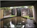
Stoke Bottom Lock
This is the lowest lock of a flight of five on the Trent and Mersey Canal in Stoke. I believe it was rebuilt here in the 1960s when the original line of the canal was moved to accommodate the new road system in the city. This lock has been fabricated out of concrete as opposed to the original which would have been made out of brick/stone.
Image: © Andy Beecroft
Taken: 10 Aug 2004
0.25 miles