Site of the Domesday Village of Pinchetel, Penkhull
Introduction
The photograph on this page of Site of the Domesday Village of Pinchetel, Penkhull by Brian Deegan as part of the Geograph project.
The Geograph project started in 2005 with the aim of publishing, organising and preserving representative images for every square kilometre of Great Britain, Ireland and the Isle of Man.

There are currently over 7.5m images from over 14,400 individuals and you can help contribute to the project by visiting https://www.geograph.org.uk
Site of the Domesday Village of Pinchetel, Penkhull
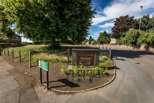
Image: © Brian Deegan Taken: 12 Jul 2020
The stone reads :- This stone marks the entrance to the former Iron Age Fort and the Domesday Village of Pinchetel a Royal Manor from 1086 to the time of Edward II The hill-top village of Penkhull was probably the earliest inhabited place within the area now known as the Potteries, being settled by the Celts, Romans and Anglo-Saxons in turn. It was ideally situated by reason of its wooded hunting grounds, its clear views over the surrounding countryside and its closeness to the streams in the Lyme Valley on the western, and the Trent Valley on the eastern side. The village may have been protected by a primitive hill-fort, although no remains of such a construction have been discovered. In 1086, the Domesday Book described the Manor of Penkhull (which it called "Pinchetel") as a village of great size, with over 1,000 acres of arable land stretched out over parts of present-day Newcastle-under-Lyme, Hanley, Shelton, Stoke and Boothen. However, soon after this survey was taken, Penkhull began to decline in importance with the building of a New Castle nearby. A market town quickly grew up within sight of this castle and by the year 1173, the Borough of Newcastle-under-Lyme ("New Castle under the Elm Trees") had been established. This borough was to remain the largest centre of population and leading market town in the area for the next 600 years until the rise of the six towns now called Stoke-on-Trent. Domesday Listed as :- PENKHULL. Earl Algar held it. 2 hides, with its dependencies. Land for 11 ploughs. In lordship 2; 17 villagers and 6 smallholders with 8 ploughs. Meadow, 2 acres; woodland 1 league long and 2 furlongs wide. Value £6.
Images are licensed for reuse under creativecommons.org/licenses/by-sa/2.0
Image Location
Latitude
53.003419
Longitude
-2.193679