IMAGES TAKEN NEAR TO
Penkhull Terrace, STOKE-ON-TRENT, ST4 5DH
Introduction
This page details the photographs taken nearby to Penkhull Terrace, ST4 5DH by members of the Geograph project.
The Geograph project started in 2005 with the aim of publishing, organising and preserving representative images for every square kilometre of Great Britain, Ireland and the Isle of Man.

There are currently over 7.5m images from over14,400 individuals and you can help contribute to the project by visiting https://www.geograph.org.uk
Image Map
Images are licensed for reuse under creativecommons.org/licenses/by-sa/2.0
Notes
- Clicking on the map will re-center to the selected point.
- The higher the marker number, the further away the image location is from the centre of the postcode.
Image Listing (35 Images Found)
Images are licensed for reuse under creativecommons.org/licenses/by-sa/2.0
Image
Details
Distance
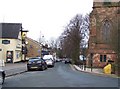
1
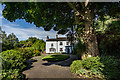
Sir Oliver Lodge Birthplace / Stanley Matthews House, Penkhull
Grade II Listed, Early C19 House
The Birth Place of Sir Oliver Lodge (1851), Pioneer of Wireless Telegraphy and inventor of the spark plug https://en.wikipedia.org/wiki/Oliver_Lodge
and
Sir Stanley Matthews CBE, football player, lived here for most of his life until his death in 2000 https://en.wikipedia.org/wiki/Stanley_Matthews
No.15 Neville Malkin's "Grand Tour" of the Potteries
http://www.thepotteries.org/tour/015.htm
Image: © Brian Deegan
Taken: 12 Jul 2020
0.09 miles
2
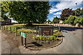
Site of the Domesday Village of Pinchetel, Penkhull
The stone reads :-
This stone marks the entrance to the former
Iron Age Fort and the Domesday Village
of
Pinchetel
a Royal Manor from 1086
to the time of Edward II
The hill-top village of Penkhull was probably the earliest inhabited place within the area now known as the Potteries, being settled by the Celts, Romans and Anglo-Saxons in turn. It was ideally situated by reason of its wooded hunting grounds, its clear views over the surrounding countryside and its closeness to the streams in the Lyme Valley on the western, and the Trent Valley on the eastern side.
The village may have been protected by a primitive hill-fort, although no remains of such a construction have been discovered. In 1086, the Domesday Book described the Manor of Penkhull (which it called "Pinchetel") as a village of great size, with over 1,000 acres of arable land stretched out over parts of present-day Newcastle-under-Lyme, Hanley, Shelton, Stoke and Boothen.
However, soon after this survey was taken, Penkhull began to decline in importance with the building of a New Castle nearby. A market town quickly grew up within sight of this castle and by the year 1173, the Borough of Newcastle-under-Lyme ("New Castle under the Elm Trees") had been established. This borough was to remain the largest centre of population and leading market town in the area for the next 600 years until the rise of the six towns now called Stoke-on-Trent.
Domesday Listed as :-
PENKHULL. Earl Algar held it. 2 hides, with its dependencies.
Land for 11 ploughs. In lordship 2;
17 villagers and 6 smallholders with 8 ploughs.
Meadow, 2 acres; woodland 1 league long and 2 furlongs wide. Value £6.
Image: © Brian Deegan
Taken: 12 Jul 2020
0.10 miles
5
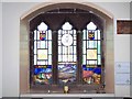
Royal Engineers Memorial Window, Penkhull Church
Image: © Geoff Pick
Taken: 24 Jan 2009
0.12 miles
6
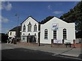
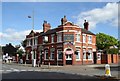
Penkhull Christian Fellowship
Built as a Primitive Methodist Chapel by public subscription in 1836, extended in 1876, closed in October 1996, restored 1998-99. So says the plaque http://www.geograph.org.uk/photo/5129592
Image: © Jonathan Hutchins
Taken: 22 Sep 2016
0.13 miles
7
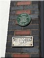
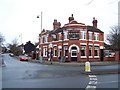
Penkhull Christian Fellowship (detail)
For the chapel itself see http://www.geograph.org.uk/photo/5129599
Image: © Jonathan Hutchins
Taken: 22 Sep 2016
0.13 miles
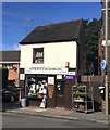
10
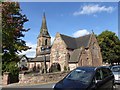
Penkhull: St Thomas' Church
By George Gilbert Scott, 1842. Grade II listed.
Historic England entry: https://www.historicengland.org.uk/listing/the-list/list-entry/1195809
Image: © Jonathan Hutchins
Taken: 22 Sep 2016
0.15 miles