IMAGES TAKEN NEAR TO
Copeland Street, STOKE-ON-TRENT, ST4 1PR
Introduction
This page details the photographs taken nearby to Copeland Street, ST4 1PR by members of the Geograph project.
The Geograph project started in 2005 with the aim of publishing, organising and preserving representative images for every square kilometre of Great Britain, Ireland and the Isle of Man.

There are currently over 7.5m images from over14,400 individuals and you can help contribute to the project by visiting https://www.geograph.org.uk
Image Map
Images are licensed for reuse under creativecommons.org/licenses/by-sa/2.0
Notes
- Clicking on the map will re-center to the selected point.
- The higher the marker number, the further away the image location is from the centre of the postcode.
Image Listing (511 Images Found)
Images are licensed for reuse under creativecommons.org/licenses/by-sa/2.0
Image
Details
Distance
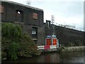
2
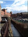
Fowlea Brook, Stoke
Fowlea Brook - is notably affected by pollution from the industrial areas through which it passes. It enters the city near Goldendale pools and is then culverted for most of its length through Longport and Etruria to Stoke, where it joins the River Trent.
To the far left is the rear of the Stoke Civic Centre and to the right is the rear yard of Spode Pottery Works
Image: © Steven Birks
Taken: 7 Mar 2003
0.05 miles
3
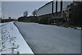
Trent & Mersey Canal
The totally frozen canal is very thick after several nights of minus figures.
Image: © Ashley Dace
Taken: 5 Dec 2010
0.06 miles

5
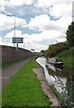
Towards Stoke Bottom Lock
The Narrowboat left Image a few minutes before the photo was taken.
Image: © Glyn Baker
Taken: 4 Sep 2011
0.07 miles
6
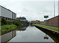
Trent and Mersey Canal in Stoke-on-Trent
Considerable redevelopment has taken place in recent years with many new factory units and multi-lane roads. There are eight lanes of the Queensway A500 behind the wall on the right! Glebe Street Bridge is ahead.
Image: © Roger D Kidd
Taken: 30 May 2011
0.07 miles
7
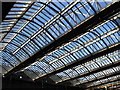
Stoke-on-Trent - Station Roof
Photo taken from south end of platform 1.
Image: © Dave Bevis
Taken: 7 Mar 2009
0.08 miles
8
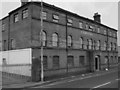
Carlton Works
Previous Earthenware and China manufacturer at the Carlton Works, Stoke, Stoke-on-Trent.
Previously the company was named "Wiltshaw & Robinson" - in January 1958 the company was renamed "Carton Ware Ltd"
Image: © Steven Birks
Taken: 14 Dec 2006
0.08 miles
9
Trent and Mersey Canal in Stoke-on-Trent
Considerable redevelopment has taken place in recent years with many new factory units and multi-lane roads. There are eight lanes of the Queensway A500 behind the wall on the right! Glebe Street Bridge is ahead.
Image: © Roger D Kidd
Taken: 30 May 2011
0.08 miles
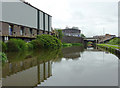
10
Reco transport platform at redevelopment site
This canalside warehouse is at the former Stoke on Trent railway goods yard. It is part the £60 million Goods Yard development by Capital & Centrica, approved in 2022.This will include housing, work spaces, a hotel, retail businesses, and public open spaces.
Image: © Christine Johnstone
Taken: 1 May 2023
0.09 miles