IMAGES TAKEN NEAR TO
Hyde Park Trading Estate, City Road, STOKE-ON-TRENT, ST4 1DS
Introduction
This page details the photographs taken nearby to Hyde Park Trading Estate, City Road, ST4 1DS by members of the Geograph project.
The Geograph project started in 2005 with the aim of publishing, organising and preserving representative images for every square kilometre of Great Britain, Ireland and the Isle of Man.

There are currently over 7.5m images from over14,400 individuals and you can help contribute to the project by visiting https://www.geograph.org.uk
Image Map
Images are licensed for reuse under creativecommons.org/licenses/by-sa/2.0
Notes
- Clicking on the map will re-center to the selected point.
- The higher the marker number, the further away the image location is from the centre of the postcode.
Image Listing (223 Images Found)
Images are licensed for reuse under creativecommons.org/licenses/by-sa/2.0
Image
Details
Distance
1
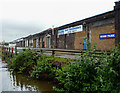
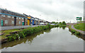
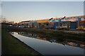
Hyde Park Trading Estate, Stoke-on-Trent
Seen from the Trent and Mersey Canal, the old works is now divided up into many smaller business units, known as the Hyde Park Trading Estate. Very little seems to be happening, so could it be that this site is due for demolition as part of the enormous ongoing regeneration of Stoke?
The site and buildings were originally the Stoke Railway Works, owned by the North Staffordshire Railway and opened in 1864.
Image: © Roger D Kidd
Taken: 30 May 2011
0.05 miles
2
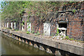
Former canal side works
Trent and Mersey Canal, south of Stoke on Trent. Industrial remains - uncertain original purpose
Image: © Mike Todd
Taken: 28 Apr 2011
0.05 miles
3
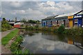
Industrial Units On the Trent & Mersey
A former factory reused as industrial units.
Image: © Glyn Baker
Taken: 4 Sep 2011
0.05 miles
4
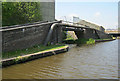
Former Access Bridge
Trent and Mersey Canal, south Stoke on Trent. The bridge originally gave access to a side arm for loading/unloading.
Image: © Mike Todd
Taken: 28 Apr 2011
0.06 miles
5
Start of the Leekbrook Branch under restoration
The Leekbrook branch was mothballed in the late 1980s. It is now being brought back into operation by Moorland & City Railways. The building in the background, "Tile Clearance House", is on the site of various former sidings and an engine shed.
Image: © Ian Calderwood
Taken: 1 Oct 2011
0.06 miles
7
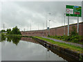
Trent and Mersey Canal in Stoke-on-Trent
Seen on a dull day after the rain had stopped!
Considerable redevelopment has taken place in recent years with many new factory units and multi-lane roads. There are eight lanes of the Queensway A500 behind the wall on the right!
The canal is 93.5 miles in length from Derwent Mouth to Preston Brook. The first sod was cut by Josiah Wedgwood in July 1766 at Middleport (Stoke-on-Trent). It took eleven years to build. This section between Derwent Mouth and Shugborough (the junction with the Staffordshire and Worcestershire Canal) was operational by 1770, the rest to Preston Brook being operational by 1777. James Brindley was the engineer until his death in 1772.
Image: © Roger D Kidd
Taken: 30 May 2011
0.06 miles
8
Trent and Mersey Canal in Stoke-on-Trent
The old works on the left is now divided up into many smaller business units, known as the Hyde Park Trading Estate. As most units seem to be closed, maybe this site is next for demolition and regeneration as part of Stoke's enormous redevelopment project.
The site and buildings were originally the Stoke Railway Works, owned by the North Staffordshire Railway and opened in 1864.
Image: © Roger D Kidd
Taken: 30 May 2011
0.06 miles
10
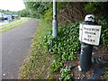
Trent & Mersey Canal Milepost in Stoke-on-Trent
Image: © Mat Fascione
Taken: 11 Jul 2015
0.06 miles