IMAGES TAKEN NEAR TO
Whittle Road, STOKE-ON-TRENT, ST3 7TU
Introduction
This page details the photographs taken nearby to Whittle Road, ST3 7TU by members of the Geograph project.
The Geograph project started in 2005 with the aim of publishing, organising and preserving representative images for every square kilometre of Great Britain, Ireland and the Isle of Man.

There are currently over 7.5m images from over14,400 individuals and you can help contribute to the project by visiting https://www.geograph.org.uk
Image Map (Loading...)


Getting Data...Please wait
Leaflet Map data © OpenStreetMap
Images are licensed for reuse under creativecommons.org/licenses/by-sa/2.0
Notes
- Clicking on the map will re-center to the selected point.
- The higher the marker number, the further away the image location is from the centre of the postcode.
Image Listing (11 Images Found)
Images are licensed for reuse under creativecommons.org/licenses/by-sa/2.0
Image
Details
Distance


5
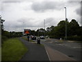
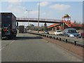
North end of Lysander Road, Meir Park
Looking towards the roundabout that provides access to the A50 and to Blythe Bridge via Uttoxeter Road.
Image: © Richard Vince
Taken: 29 Jun 2013
0.21 miles
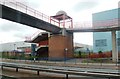
9
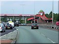
Red Footbridge over Uttoxeter Road at Meir
Image: © David Dixon
Taken: 8 Aug 2014
0.23 miles
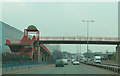
10
A50 - domed footbridge at Edenhurst Avenue
In dualling the A50 between Blythe Bridge and the A500, the builders employed a series of interesting footbridge designs. This is the first, with domes over the abutments.
Image: © Peter Whatley
Taken: 24 Mar 2011
0.23 miles