IMAGES TAKEN NEAR TO
Cocknage Road, STOKE-ON-TRENT, ST3 7NN
Introduction
This page details the photographs taken nearby to Cocknage Road, ST3 7NN by members of the Geograph project.
The Geograph project started in 2005 with the aim of publishing, organising and preserving representative images for every square kilometre of Great Britain, Ireland and the Isle of Man.

There are currently over 7.5m images from over14,400 individuals and you can help contribute to the project by visiting https://www.geograph.org.uk
Image Map (Loading...)


Getting Data...Please wait
Leaflet Map data © OpenStreetMap
Images are licensed for reuse under creativecommons.org/licenses/by-sa/2.0
Notes
- Clicking on the map will re-center to the selected point.
- The higher the marker number, the further away the image location is from the centre of the postcode.
Image Listing (4 Images Found)
Images are licensed for reuse under creativecommons.org/licenses/by-sa/2.0
Image
Details
Distance
1
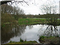
Pond at Barlaston Common
Located in Rough Close between Stoke on Trent and Stone it is known as Rough Close Common, Pond.
Image: © Phil Eptlett
Taken: 26 Apr 2006
0.17 miles
3
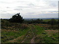
Rough Close
Just visible (if you look VERY hard in a direct continuation from the path!) is The Wrekin, about 30 miles away
Image: © Linda Mellor
Taken: 26 Sep 2005
0.25 miles