IMAGES TAKEN NEAR TO
Ridge Crescent, STOKE-ON-TRENT, ST3 7LG
Introduction
This page details the photographs taken nearby to Ridge Crescent, ST3 7LG by members of the Geograph project.
The Geograph project started in 2005 with the aim of publishing, organising and preserving representative images for every square kilometre of Great Britain, Ireland and the Isle of Man.

There are currently over 7.5m images from over14,400 individuals and you can help contribute to the project by visiting https://www.geograph.org.uk
Image Map (Loading...)


Getting Data...Please wait
Leaflet Map data © OpenStreetMap
Images are licensed for reuse under creativecommons.org/licenses/by-sa/2.0
Notes
- Clicking on the map will re-center to the selected point.
- The higher the marker number, the further away the image location is from the centre of the postcode.
Image Listing (9 Images Found)
Images are licensed for reuse under creativecommons.org/licenses/by-sa/2.0
Image
Details
Distance
1
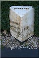
Old Milepost by the A520, Sandon Road, Meir Heath
Cast iron post by the A520, in parish of STOKE ON TRENT (STOKE ON TRENT District), Meir Heath, in tarmac path in front of garden, on East side of road. Lathe iron casting, erected by the County Council in the 19th/20th century.
Inscription reads:- : HILDERSTONE 4 / SANDON 7½ / STAFFORD 12 : : NORMACOT : : LEEK 11½ : : Chas. Lathe, Tipton. :
Milestone Society National ID: ST_STLK12.
Image: © J Higgins
Taken: 1 Jan 2000
0.06 miles
2
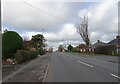
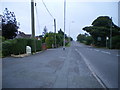
Sandon Road
The view along the A520 road in Meir Heath, Staffordshire.
Image: © Gordon Griffiths
Taken: 19 Nov 2021
0.06 miles
3
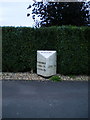
Meir Heath milepost - detail
Clearly (and I reckon incorrectly) telling us that it's in Normacot.
Image: © Richard Law
Taken: 8 Sep 2009
0.11 miles
4
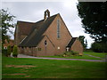
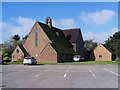
The church of St Francis of Assisi, Meir Heath
Image: © Richard Law
Taken: 15 Sep 2009
0.12 miles
5
Meir Heath milepost in its setting
Oddly, despite being in Meir Heath, this one has the name 'Normacot' on it (see Image), which is about 1.5 miles away to the northwest. Makes you wonder if it's been moved at some time in the past.
Image: © Richard Law
Taken: 8 Sep 2009
0.12 miles
7
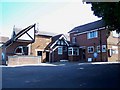
St. Matthew's School, Rough Close, Meir Heath
The school has a small church attached
Image: © Geoff Pick
Taken: 24 Aug 2007
0.18 miles
8
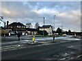
Post Office at Meir Heath
Pictured from a usually busy intersection on Windmill Hill. The post office is in the centre of picture and the still-surviving windmill itself is out of picture to the right.
Image: © Jonathan Clitheroe
Taken: 21 Jan 2021
0.21 miles
9
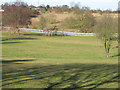
Grindley Park
Houses in the distance are Sandon Road.[Looking NNW]
Image: © John Thorn
Taken: 9 Feb 2006
0.22 miles