
IMAGES TAKEN NEAR TO
Meir Road, STOKE-ON-TRENT, ST3 7JB
Introduction
This page details the photographs taken nearby to Meir Road, ST3 7JB by members of the Geograph project.
The Geograph project started in 2005 with the aim of publishing, organising and preserving representative images for every square kilometre of Great Britain, Ireland and the Isle of Man.

There are currently over 7.5m images from over14,400 individuals and you can help contribute to the project by visiting https://www.geograph.org.uk
Image Map
Images are licensed for reuse under creativecommons.org/licenses/by-sa/2.0
Notes
- Clicking on the map will re-center to the selected point.
- The higher the marker number, the further away the image location is from the centre of the postcode.
Image Listing (24 Images Found)
Images are licensed for reuse under creativecommons.org/licenses/by-sa/2.0
Image
Details
Distance
2
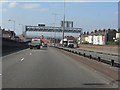
A50 descending toward Normacot
The photo illustrates some of the destruction to the local area wrought by the A50 dualling scheme. A crying shame that the earlier proposal for the M64 was not implemented instead (see http://pathetic.org.uk/unbuilt/m64/ for details).
Image: © Peter Whatley
Taken: 24 Mar 2011
0.10 miles
3
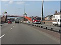
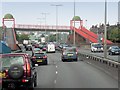
A50 - domed footbridge off Box Lane
In dualling the A50 between Blythe Bridge and the A500, the builders employed a series of interesting footbridge designs. This is the first, with domes over the abutments. For a similar example, see: http://www.geograph.org.uk/photo/2342380 .
Image: © Peter Whatley
Taken: 24 Mar 2011
0.11 miles
5
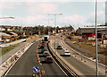
New A50 Normacot (under construction)
Meir's Holy Trinity church is in the distance, while to the right is the Royal Mail sorting office. Taken during the summer of 1997 from the newly finished road bridge at the Normacot junction of the A50.
Image: © Chris Beaver
Taken: Unknown
0.12 miles
7
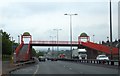
Footbridge with cupolas over A50
One of several unusual footbridges over the A50 dual carriageway. There is convenient bus stop by the slope up to the bridge deck
Image: © David Smith
Taken: 23 Jul 2013
0.13 miles
9
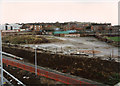
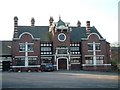
Original site of Alexandra CP School
Taken in 1997 during the construction of the new A50 trunk road, this photo shows the derelict site formerly occupied by the original Alexandra County Primary school. This was demolished in about 1995 when a replacement school had opened nearby in Meir Road. The tarmaced area was the playground with prefab classrooms occupying the foreground area. The main school building stood where the pile of bricks is. To the left is the Royal Mail delivery depot. At the present time (2012) this site is still derelict but much more overgrown than in this photo. See also the photo of the school during demolition.
Image: © Chris Beaver
Taken: Unknown
0.16 miles
10
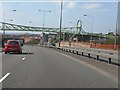
A50 - footbridge off Recreation Road
In dualling the A50 between Blythe Bridge and the A500, the builders employed a series of interesting footbridge designs. This is the third type, a single steelwork span with abutments surmounted by large "O-rings" that carry lights.
Image: © Peter Whatley
Taken: 24 Mar 2011
0.18 miles