IMAGES TAKEN NEAR TO
Hawk Close, STOKE-ON-TRENT, ST3 7GB
Introduction
This page details the photographs taken nearby to Hawk Close, ST3 7GB by members of the Geograph project.
The Geograph project started in 2005 with the aim of publishing, organising and preserving representative images for every square kilometre of Great Britain, Ireland and the Isle of Man.

There are currently over 7.5m images from over14,400 individuals and you can help contribute to the project by visiting https://www.geograph.org.uk
Image Map
Images are licensed for reuse under creativecommons.org/licenses/by-sa/2.0
Notes
- Clicking on the map will re-center to the selected point.
- The higher the marker number, the further away the image location is from the centre of the postcode.
Image Listing (4 Images Found)
Images are licensed for reuse under creativecommons.org/licenses/by-sa/2.0
Image
Details
Distance
1
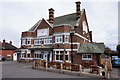
Saracens Head
On Sandon Road, Stoke-on-Trent. http://www.geograph.org.uk/photo/4891956
Image: © Ian S
Taken: 29 Mar 2016
0.14 miles
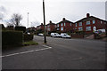
2

Saracens Head
On Sandon Road, Stoke-on-Trent. http://www.geograph.org.uk/photo/4891954
Image: © Ian S
Taken: 29 Mar 2016
0.15 miles
4
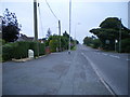
Meir Heath milepost in its setting
Oddly, despite being in Meir Heath, this one has the name 'Normacot' on it (see Image), which is about 1.5 miles away to the northwest. Makes you wonder if it's been moved at some time in the past.
Image: © Richard Law
Taken: 8 Sep 2009
0.25 miles