
IMAGES TAKEN NEAR TO
Kingsley Street, STOKE-ON-TRENT, ST3 6DG
Introduction
This page details the photographs taken nearby to Kingsley Street, ST3 6DG by members of the Geograph project.
The Geograph project started in 2005 with the aim of publishing, organising and preserving representative images for every square kilometre of Great Britain, Ireland and the Isle of Man.

There are currently over 7.5m images from over14,400 individuals and you can help contribute to the project by visiting https://www.geograph.org.uk
Image Map
Images are licensed for reuse under creativecommons.org/licenses/by-sa/2.0
Notes
- Clicking on the map will re-center to the selected point.
- The higher the marker number, the further away the image location is from the centre of the postcode.
Image Listing (22 Images Found)
Images are licensed for reuse under creativecommons.org/licenses/by-sa/2.0
Image
Details
Distance
1
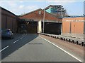
A50 - Eastern entrance to Meir Tunnel
Although the basic structures here are all formed from concrete, an attempt has been made to soften the new road's impact by erecting a screen wall in brickwork, including a decorative Staffordshire knot above the tunnel portal.
Image: © Peter Whatley
Taken: 24 Mar 2011
0.15 miles
2
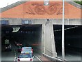
A50, Entrance to the Meir Tunnel
Meir Tunnel, which is 284 metres long, forms part of the upgrading of the A50, through a heavily trafficked urban area of Stoke-on-Trent. The tunnel is self-ventilating; varying levels of lighting are provided.
Above the entrance to the tunnel is the Stoke-on-Trent Coat of Arms and a Stafford Knot inside which are the hands of a potter an on the left and the fire of industry on the right. The tools of the potter are depicted on each side of the knot.
Image: © David Dixon
Taken: 8 Aug 2014
0.15 miles
3
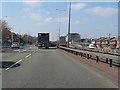
A50 approaching Meir Tunnel
The start of the massively intrusive A50 dualling from Meir to the A500. A scheme which would have been wholly unnecessary had the original plans for an M64 connection between the M6 and M1 been pursued (see http://pathetic.org.uk/unbuilt/m64/ for details).
Image: © Peter Whatley
Taken: 24 Mar 2011
0.15 miles
4
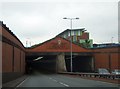
Entrance to A50 Meir Tunnel under A520
The portal is faced with bricks
Image: © David Smith
Taken: 23 Jul 2013
0.15 miles
5
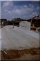
A50 Meir tunnel - east portal
Taken as part of a GCSE school project this photo shows the Meir tunnel under construction and the A50 upgrades in about 1997.
Image: © David Beaver
Taken: Unknown
0.16 miles
6

King's Arms pub and Weston Road
Taken during the A50 tunnel construction in about 1997 this view up Weston Road shows the now-demolished King's Arms public house on the right. This building has since been replaced by the new Meir Health Centre which opened in 2011.
Image: © David Beaver
Taken: Unknown
0.16 miles
7
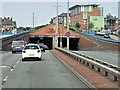
Uttoxeter Road Approaching Entrance to Meir Tunnel
Meir Tunnel, which is 284 metres long, forms part of the upgrading of the A50, through a heavily trafficked urban area of Stoke-on-Trent.
Image: © David Dixon
Taken: 8 Aug 2014
0.16 miles
8
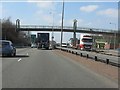
A50 - footbridge at Grangewood Road
In dualling the A50 between Blythe Bridge and the A500, the builders employed a series of interesting footbridge designs. This is the second, a basic structure enlivened with large diameter "O-rings" which carry lighting above simple supporting pillars .
Image: © Peter Whatley
Taken: 24 Mar 2011
0.18 miles
9
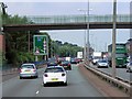
Green Footbridge over Uttoxeter Road at Meir
Image: © David Dixon
Taken: 8 Aug 2014
0.18 miles
10
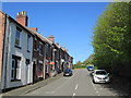
Meir View
Meir View, a street near the town centre.
Image: © David Weston
Taken: 3 May 2017
0.18 miles