IMAGES TAKEN NEAR TO
Lightwood Road, STOKE-ON-TRENT, ST3 4JH
Introduction
This page details the photographs taken nearby to Lightwood Road, ST3 4JH by members of the Geograph project.
The Geograph project started in 2005 with the aim of publishing, organising and preserving representative images for every square kilometre of Great Britain, Ireland and the Isle of Man.

There are currently over 7.5m images from over14,400 individuals and you can help contribute to the project by visiting https://www.geograph.org.uk
Image Map
Images are licensed for reuse under creativecommons.org/licenses/by-sa/2.0
Notes
- Clicking on the map will re-center to the selected point.
- The higher the marker number, the further away the image location is from the centre of the postcode.
Image Listing (65 Images Found)
Images are licensed for reuse under creativecommons.org/licenses/by-sa/2.0
Image
Details
Distance
2
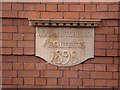
Date Plaque on Sutherland Institute
Wood & Hutchings, Architects, 1898
Date plaque on the side of the Sutherland Institute, Longton.
See the Sutherland Institute: http://www.geograph.org.uk/photo/122101
Image: © Steven Birks
Taken: 19 Sep 2006
0.07 miles
5
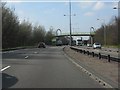
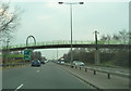
A50 - footbridge west of the Normacot junction
In dualling the A50 between Blythe Bridge and the A500, the builders employed a series of interesting footbridge designs. This is the second, a basic structure enlivened with large diameter "O-rings" which carry lighting above simple supporting pillars. For another example, see: http://www.geograph.org.uk/photo/2342422 .
Image: © Peter Whatley
Taken: 24 Mar 2011
0.12 miles
6
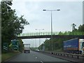
A50 - footbridge close-up
The same footbridge as in http://www.geograph.org.uk/photo/2342480 in close-up.
Image: © Peter Whatley
Taken: 24 Mar 2011
0.12 miles
7
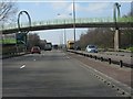
Footbridge over A50 between Lloyd and Warren Streets
The bridge connects the two parts of a former road, now cut short by the A50
Image: © David Smith
Taken: 23 Jul 2013
0.12 miles
8
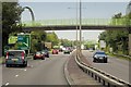
Lockett's Lane Footbridge, Uttoxeter Road
Image: © David Dixon
Taken: 8 Aug 2014
0.12 miles

10
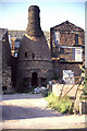
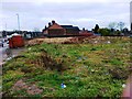
Bottle oven, Minkstone Works, Longton
All the surviving bottle ovens are now listed.
At least one has been lost since 1989 (Fountain place Works, Burslem).
Image: © Chris Allen
Taken: Unknown
0.13 miles