IMAGES TAKEN NEAR TO
Little Cliffe Road, STOKE-ON-TRENT, ST3 2DN
Introduction
This page details the photographs taken nearby to Little Cliffe Road, ST3 2DN by members of the Geograph project.
The Geograph project started in 2005 with the aim of publishing, organising and preserving representative images for every square kilometre of Great Britain, Ireland and the Isle of Man.

There are currently over 7.5m images from over14,400 individuals and you can help contribute to the project by visiting https://www.geograph.org.uk
Image Map (Loading...)


Getting Data...Please wait
Leaflet Map data © OpenStreetMap
Images are licensed for reuse under creativecommons.org/licenses/by-sa/2.0
Notes
- Clicking on the map will re-center to the selected point.
- The higher the marker number, the further away the image location is from the centre of the postcode.
Image Listing (15 Images Found)
Images are licensed for reuse under creativecommons.org/licenses/by-sa/2.0
Image
Details
Distance
1
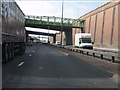
A50 - hidden footbridge at Heron Cross
A remarkable structure amidst the Heron Cross road system which springs directly from the cutting walls and presumably provides access under the roads which parallel either side of the A50. You need a 1:25k map to identify the footbridge's location as the 1:50k map simply can't fit it in!
Image: © Peter Whatley
Taken: 24 Mar 2011
0.12 miles
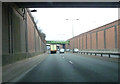
3
Footbridge at Heron Cross
The last mile of the A50 towards Stoke-on-Trent (past Stoke City FC's Britannia Stadium) is a spur which ends at the junction with the A500; the northbound A50 continues from the roundabout at Heron Cross.
Image: © David Dixon
Taken: 8 Aug 2014
0.14 miles
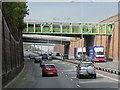
4
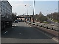
A50 approaching Heron Cross junctions
Image: © Peter Whatley
Taken: 24 Mar 2011
0.19 miles
5
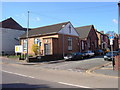
Blurton Free Baptist Church
The church stands on the junction of Blurton Road and Bourne Street. It began life as a Primitive Methodist Church towards the end of the 19th century and is still in use today by a group of local Christians. The nearest part of the building is the newest, the furthest is the original building.
Image: © andrew
Taken: 10 Jun 2006
0.20 miles
6
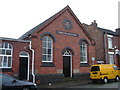
Blurton Free Baptist Church
This is the original building. Put up in 1878 as a Primitive Methodist Church a group of local Christians use it today. The door pictured is no longer in use.
Image: © andrew
Taken: 10 Nov 2004
0.20 miles
7
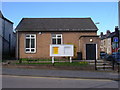
Blurton Free Baptist Church
This is the most modern part of the church, fronting onto Blurton Road. It was put up post WW2, I believe. This is the entrance now used to access the chapel.
Image: © andrew
Taken: 5 Apr 2006
0.20 miles
8
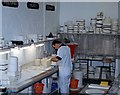
Inside Burslem Pottery
The city was scattered with potteries, which was by far the biggest industry in this area. Now very few remain - even fewer are in use.
This one is being used by Burslem Pottery now - who make art ware.
Image: © Debbie Turner
Taken: 15 Oct 2007
0.20 miles
10
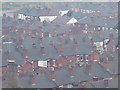
View over Heron Cross from Glebedale Park
Over the bottle oven of the local pottery and the roofs of the houses you can see the roof of Blurton Baptist Church and beyond the roundabout over the A 50.
Image: © andrew
Taken: 28 Mar 2005
0.21 miles