IMAGES TAKEN NEAR TO
Cresswell Lane, STAFFORD, ST19 9BE
Introduction
This page details the photographs taken nearby to Cresswell Lane, ST19 9BE by members of the Geograph project.
The Geograph project started in 2005 with the aim of publishing, organising and preserving representative images for every square kilometre of Great Britain, Ireland and the Isle of Man.

There are currently over 7.5m images from over14,400 individuals and you can help contribute to the project by visiting https://www.geograph.org.uk
Image Map
Images are licensed for reuse under creativecommons.org/licenses/by-sa/2.0
Notes
- Clicking on the map will re-center to the selected point.
- The higher the marker number, the further away the image location is from the centre of the postcode.
Image Listing (157 Images Found)
Images are licensed for reuse under creativecommons.org/licenses/by-sa/2.0
Image
Details
Distance
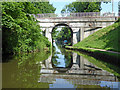
1

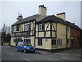
Bridge Inn
The Pub stands next to the Shropshire Union Canal.
Image: © Gordon Griffiths
Taken: 23 Nov 2007
0.01 miles
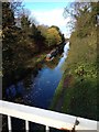
3
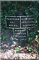
Old milemarker north of Brewood Bridge
Milemarker by the Shropshire Union Canal, in parish of Brewood (South Staffordshire District), North of Brewood Bridge.
Inscription reads:-
:NANTWICH/34./MILES.: :NORBURY./JUNCTION./10½,MILES.: :AUTHERLEY./JUNCTION./5.MILES:
Grade II listed.
List Entry Number: 1374012 https://historicengland.org.uk/listing/the-list/list-entry/1374012
Surveyed
Milestone Society National ID: SUC-05
Image: © Milestone Society
Taken: Unknown
0.02 miles
4
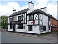
The Bridge Inn
The Bridge Inn beside the Shropshire Union Canal in Brewood.
Image: © Philip Halling
Taken: 7 Jul 2019
0.03 miles
5
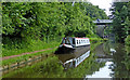
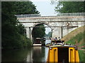
Shropshire Union Canal near Brewood in Staffordshire
There are good visitor moorings at Brewood. Ahead is Brewood Bridge, No 14 about ten metres from the pub!
Image: © Roger D Kidd
Taken: 9 Jun 2018
0.03 miles
6
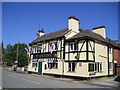
The Bridge Inn Pub, Brewood
High Green, Brewood STAFFORD ST19 1BD on The Shropshire Union Canal
Image: © canalandriversidepubs co uk
Taken: 16 Jun 2010
0.03 miles
8
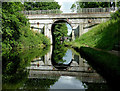
Brewood Bridge No.14 Shropshire Union Canal 2005
Opened in 1835, the Birmingham & Liverpool Junction Canal merged with the competing railway company in 1845 it then became the Shropshire Union Railways and Canal Co.
NICHOLSON Guide to the Waterways - book 4.
"Brewood" - pronounced "Brood"
Image: © Maurice Pullin
Taken: 18 Aug 2005
0.04 miles
9
Brewood Bridge at Brewood, Staffordshire
Brewood Bridge is No 14 across the Shropshire Union canal. It carries Kiddemore Green Road which becomes Bargate Street off to the right.
Image: © Roger D Kidd
Taken: 7 Jul 2014
0.04 miles
10
Brewood Bridge in Staffordshire
Brewood Bridge is No 14 across the Shropshire Union Canal. To the right is Bargate Street towards Brewood village; to the left, Kiddemore Green Road leads to Bishop's Wood.
Image: © Roger D Kidd
Taken: 3 Jun 2018
0.04 miles