IMAGES TAKEN NEAR TO
Williams Paddock, ST19 5FW
Introduction
This page details the photographs taken nearby to Williams Paddock, ST19 5FW by members of the Geograph project.
The Geograph project started in 2005 with the aim of publishing, organising and preserving representative images for every square kilometre of Great Britain, Ireland and the Isle of Man.

There are currently over 7.5m images from over14,400 individuals and you can help contribute to the project by visiting https://www.geograph.org.uk
Image Map (Loading...)


Getting Data...Please wait
Leaflet Map data © OpenStreetMap
Images are licensed for reuse under creativecommons.org/licenses/by-sa/2.0
Notes
- Clicking on the map will re-center to the selected point.
- The higher the marker number, the further away the image location is from the centre of the postcode.
Image Listing (11 Images Found)
Images are licensed for reuse under creativecommons.org/licenses/by-sa/2.0
Image
Details
Distance
1
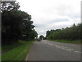
A449 heading towards Penkridge in Staffordshire
Image: © James Denham
Taken: 3 Aug 2009
0.11 miles
2
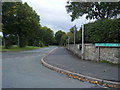
Levedale Road/Goods Station Lane junction
Image: © Colin Pyle
Taken: 10 Sep 2010
0.14 miles
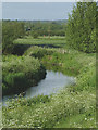
4
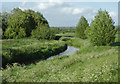
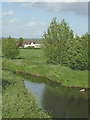
The River Penk at Penkridge, Staffordshire
The river is seen here from the A449 at Bull Bridge.
The River Penk has its source in Perton three miles from Wolverhampton. Its course is mainly through South Staffordshire draining most of the northern part of that district, together with some adjoining areas of Cannock Chase, Stafford, Wolverhampton, and Shropshire. It flows into the River Sow, which is a tributary of the River Trent, so its waters flow eventually into the North Sea via the Humber Estuary. (Details from http://en.wikipedia.org/wiki/River_Penk )
Image: © Roger D Kidd
Taken: 24 May 2011
0.20 miles
5
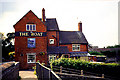
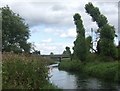
The Boat Pub and Bridge
This pub has been around for a long while on this canal and now serves narrow boat holidayers as well as locals. It is situated at the bridge, in the southern section of the grid square.
Image: © Pam Brophy
Taken: Unknown
0.22 miles
6
The River Penk at Penkridge, Staffordshire
The river is seen here with telephoto assistance from the A449 at Bull Bridge.
The River Penk has its source in Perton three miles from Wolverhampton. Its course is mainly through South Staffordshire draining most of the northern part of that district, together with some adjoining areas of Cannock Chase, Stafford, Wolverhampton, and Shropshire. It flows into the River Sow, which is a tributary of the River Trent, so its waters flow eventually into the North Sea via the Humber Estuary. (Details from http://en.wikipedia.org/wiki/River_Penk )
Image: © Roger D Kidd
Taken: 24 May 2011
0.22 miles
7
The River Penk at Penkridge, Staffordshire
The river is seen here from the A449 at Bull Bridge.
The River Penk has its source in Perton three miles from Wolverhampton. Its course is mainly through South Staffordshire draining most of the northern part of that district, together with some adjoining areas of Cannock Chase, Stafford, Wolverhampton, and Shropshire. It flows into the River Sow, which is a tributary of the River Trent, so its waters flow eventually into the North Sea via the Humber Estuary. (Details from http://en.wikipedia.org/wiki/River_Penk )
Image: © Roger D Kidd
Taken: 24 May 2011
0.22 miles
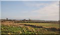
8
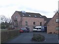
Roller Mill
Converted watermill now used as a day centre by Age Concern. The mill appears some distance from the current channel of the River Penk but maybe had long mill leats.
Image: © John M
Taken: 3 Apr 2010
0.22 miles
9
The River Penk at Penkridge, Staffordshire
The river is seen here from the A449 at Bull Bridge.
The River Penk has its source in Perton three miles from Wolverhampton. Its course is mainly through South Staffordshire draining most of the northern part of that district, together with some adjoining areas of Cannock Chase, Stafford, Wolverhampton, and Shropshire. It flows into the River Sow, which is a tributary of the River Trent, so its waters flow eventually into the North Sea via the Humber Estuary. (Details from http://en.wikipedia.org/wiki/River_Penk )
Image: © Roger D Kidd
Taken: 24 May 2011
0.23 miles
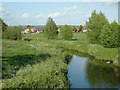
10
River Penk downstream at Penkridge
Looking towards the A449 bridge.
Image: © John M
Taken: 15 Aug 2009
0.24 miles