IMAGES TAKEN NEAR TO
Frederick Road, STAFFORD, ST19 5BL
Introduction
This page details the photographs taken nearby to Frederick Road, ST19 5BL by members of the Geograph project.
The Geograph project started in 2005 with the aim of publishing, organising and preserving representative images for every square kilometre of Great Britain, Ireland and the Isle of Man.

There are currently over 7.5m images from over14,400 individuals and you can help contribute to the project by visiting https://www.geograph.org.uk
Image Map
Images are licensed for reuse under creativecommons.org/licenses/by-sa/2.0
Notes
- Clicking on the map will re-center to the selected point.
- The higher the marker number, the further away the image location is from the centre of the postcode.
Image Listing (69 Images Found)
Images are licensed for reuse under creativecommons.org/licenses/by-sa/2.0
Image
Details
Distance
1
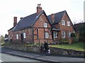
Millend Cottage
An example of a 16th century timber framed cottage with later brick infill. The slate roof probably dates from 1984 together with the building to the rear.
For a glimpse of the original construction see http://www.bagnallvillage.com/Pages/millend.htm
Image: © John M
Taken: 3 Apr 2010
0.09 miles
2
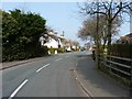
Looking north along Marsh Lane, Penkridge
Image: © Richard Law
Taken: 22 Mar 2012
0.10 miles
3
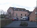
Roller Mill
Converted watermill now used as a day centre by Age Concern. The mill appears some distance from the current channel of the River Penk but maybe had long mill leats.
Image: © John M
Taken: 3 Apr 2010
0.13 miles
4
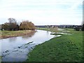
River Penk in flood at Penkridge
This is looking east from the A449 road bridge
Image: © Stephen Grice
Taken: 16 Jan 2008
0.15 miles
5
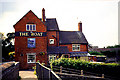
The Boat Pub and Bridge
This pub has been around for a long while on this canal and now serves narrow boat holidayers as well as locals. It is situated at the bridge, in the southern section of the grid square.
Image: © Pam Brophy
Taken: Unknown
0.16 miles
6
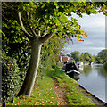
Visitor moorings at Penkridge in Staffordshire
There are good moorings here north of Penkridge Bridge.
Image: © Roger D Kidd
Taken: 7 Oct 2017
0.18 miles
7
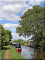
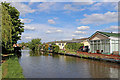
Canal in Penkridge, Staffordshire
This is the Staffordshire and Worcestershire Canal in Penkridge, looking north-east towards Stafford and Great Haywood. There are plenty of visitor moorings here if you can't find a place south of Penkridge Lock.
Image: © Roger Kidd
Taken: 22 May 2019
0.18 miles
8
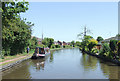
Staffordshire and Worcestershire Canal at Penkridge, Staffordshire
The Staffordshire and Worcestershire Canal was opened in 1772, and engineered by James Brindley. It cost a little over £100,000 at the time for its 46 mile course from Stourport to Great Haywood. There is plenty of mooring space for visitors. Try the Star in the village for well kept ale - the Bridge Inn is an eatery which can be noisy in the evenings.
Image: © Roger D Kidd
Taken: 21 Jun 2010
0.18 miles
9
Canal at Penkridge in Staffordshire
This is the Staffordshire and Worcestershire Canal in Penkridge, looking towards Stafford and Great Haywood. The smartly maintained mobile homes are in Little Marsh Park.
Image: © Roger Kidd
Taken: 22 May 2019
0.18 miles
10
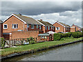
Canalside housing in Penkridge, Staffordshire
The housing by the Staffordshire and Worcestershire Canal is in Leacroft Road, in the area known as The Marsh.
Image: © Roger Kidd
Taken: 28 Jul 2015
0.18 miles