IMAGES TAKEN NEAR TO
Brook Side, STAFFORD, ST18 9JA
Introduction
This page details the photographs taken nearby to Brook Side, ST18 9JA by members of the Geograph project.
The Geograph project started in 2005 with the aim of publishing, organising and preserving representative images for every square kilometre of Great Britain, Ireland and the Isle of Man.

There are currently over 7.5m images from over14,400 individuals and you can help contribute to the project by visiting https://www.geograph.org.uk
Image Map (Loading...)


Getting Data...Please wait
Leaflet Map data © OpenStreetMap
Images are licensed for reuse under creativecommons.org/licenses/by-sa/2.0
Notes
- Clicking on the map will re-center to the selected point.
- The higher the marker number, the further away the image location is from the centre of the postcode.
Image Listing (10 Images Found)
Images are licensed for reuse under creativecommons.org/licenses/by-sa/2.0
Image
Details
Distance
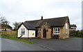
1
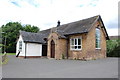
Building in Ranton
Was this a place of Worship or a Schoolhouse.
Image: © Mick Malpass
Taken: 19 Jun 2011
0.07 miles
3
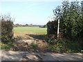
Footpath across a sown field, Ranton
The line of the footpath to Clanford Hall is unmarked across the field. I think this path will have to be walked on another day.
Image: © John M
Taken: 21 Oct 2007
0.09 miles
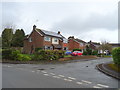
6
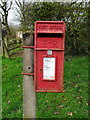
Elizabeth II postbox on Brook Lane, Ranton
Postbox No. ST18 98.
Image: © JThomas
Taken: 14 Mar 2020
0.11 miles
7
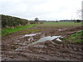
Muddy field and hedgerow, Ranton
Off Coton Lane.
Image: © JThomas
Taken: 14 Mar 2020
0.11 miles
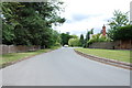
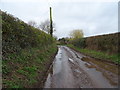
8
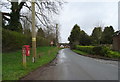
Brook Lane, Ranton
Junction with Church Close.
Image: © JThomas
Taken: 14 Mar 2020
0.12 miles
10
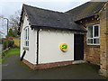
Defibrillator on Ranton Village Hall
See Image] for context.
Image: © JThomas
Taken: 14 Mar 2020
0.17 miles