IMAGES TAKEN NEAR TO
Haughton Grange, STAFFORD, ST18 9FE
Introduction
This page details the photographs taken nearby to Haughton Grange, ST18 9FE by members of the Geograph project.
The Geograph project started in 2005 with the aim of publishing, organising and preserving representative images for every square kilometre of Great Britain, Ireland and the Isle of Man.

There are currently over 7.5m images from over14,400 individuals and you can help contribute to the project by visiting https://www.geograph.org.uk
Image Map (Loading...)


Getting Data...Please wait
Leaflet Map data © OpenStreetMap
Images are licensed for reuse under creativecommons.org/licenses/by-sa/2.0
Notes
- Clicking on the map will re-center to the selected point.
- The higher the marker number, the further away the image location is from the centre of the postcode.
Image Listing (16 Images Found)
Images are licensed for reuse under creativecommons.org/licenses/by-sa/2.0
Image
Details
Distance
2
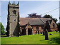
St Giles', Haughton
The church is built of brick and the tower of stone.
Image: © Eirian Evans
Taken: 5 Jun 2006
0.09 miles
3
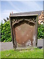
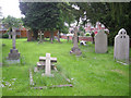
Prepare to meet thy doom!
This red sandstone gravestone in Haughton churchyard has the following verse-
"The grave has eloquence its lectures teach
In silence louder than devines can preach
Hear what it says ye sons of folly hear
It speaks to you lend an attentive ear
Prepare! prepare! prepare! to die"
Image: © Eirian Evans
Taken: 5 Jun 2006
0.09 miles
6
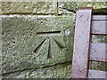
OS bolt and benchmark - Haughton, St Gile's church
A 1st Primary Levelling bolt, and associated more recent cutmark, on the south face of the church tower. It was placed in late 1858 as part of the Llandysilio to Stafford levelling line at a height of 346' 7.5" above Ordnance Datum Liverpool.
Image: © Richard Law
Taken: 9 Apr 2016
0.13 miles
7
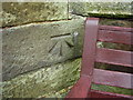
Ordnance Survey bolt on St Giles Church
This bench mark is on the south face of buttress at the south-west corner of tower, and was established in 1858 during the First primary levelling, England & Wales. It was levelled with a height of 346.6280 feet [105.6522 metres] above mean sea level (Liverpool datum). It was included on the Llandysilio to Stafford levelling line. The surveyor's description was No. 102. Bolt in South-west angle of Haughton Church tower ; 2.47 ft. above surface (p588).
Image: © Shantavira
Taken: 16 Aug 2013
0.13 miles
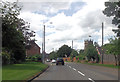
8
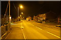
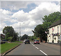
The A518 passing through Haughton
The main road through the village at its junction with Station Road. When there was a station, it was a little way outside the village on the Stafford to Shrewsbury line which is now closed and has been made into a cycle route.
Image: © Bill Boaden
Taken: 13 Jan 2018
0.13 miles
10
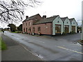
The Shropshire Inn
Despite its location in Staffs, the Shropshire appears to be thriving, and has quite a reputation as a local dining destination.
Image: © Richard Law
Taken: 9 Apr 2016
0.17 miles