IMAGES TAKEN NEAR TO
Milwich, STAFFORD, ST18 0EG
Introduction
This page details the photographs taken nearby to ST18 0EG by members of the Geograph project.
The Geograph project started in 2005 with the aim of publishing, organising and preserving representative images for every square kilometre of Great Britain, Ireland and the Isle of Man.

There are currently over 7.5m images from over14,400 individuals and you can help contribute to the project by visiting https://www.geograph.org.uk
Image Map
Images are licensed for reuse under creativecommons.org/licenses/by-sa/2.0
Notes
- Clicking on the map will re-center to the selected point.
- The higher the marker number, the further away the image location is from the centre of the postcode.
Image Listing (23 Images Found)
Images are licensed for reuse under creativecommons.org/licenses/by-sa/2.0
Image
Details
Distance
1
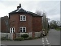
Old Toll House, Milwich
Toll House in the parish of Milwich, The Round House, Main Street, ST18 0EG.
Grade II listed.
List Entry Number: 1189551 https://historicengland.org.uk/listing/the-list/list-entry/1189551
Surveyed
Milestone Society National ID: ST.MIL
Image: © Milestone Society
Taken: Unknown
0.00 miles
2
Old school building at Milwich
Above the doors facing the road are the signs "Infants and girls school AD 1833" and "Boys school AD 1833". It was a school until 1929.
Image: © David Weston
Taken: 23 May 2018
0.01 miles
3
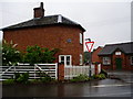
The Toll House, Milwich
Built in 1793, this was the tollhouse for the turnpiked Stone to Uttoxeter road.
Image: © Eirian Evans
Taken: 5 Aug 2008
0.01 miles
4
Old School, Milwich
Two doors for the school, one for boys on the right and the other for girls and infants.
Image: © Eirian Evans
Taken: 5 Aug 2008
0.01 miles
5
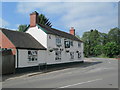
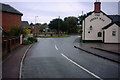
The Green Man, Milwich
A pub in Milwich. On the right is Sandon Lane, leading towards All Saints' Church.
Image: © David Weston
Taken: 23 May 2018
0.01 miles
6
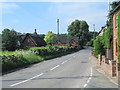
The B5027 through Milwich
Looking south-west from the junction with The Allways.
Image: © David Weston
Taken: 23 May 2018
0.07 miles
7
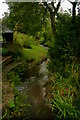
A Village Stream
This is a view of a stream through the village of Marston, taken from the bridge on the main road.
Image: © Stephen Pearce
Taken: 27 Oct 2006
0.07 miles
8
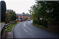
The Road into Milwich
This is the lane into Milwich from Sandon. A photo from this bridge over the stream (to the left) is also submitted.
Image: © Stephen Pearce
Taken: 27 Oct 2006
0.07 miles
9
A Village Public House
The Green Man in the centre of Milwich Village. The road ahead is the B5027 from Stone to Uttoxeter. Just out of view on the junction is an old school, a photo is submitted.
Image: © Stephen Pearce
Taken: 27 Oct 2006
0.07 miles
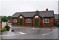
10
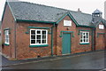
The 'Old' School
This old school in the centre of the village of Milwich shows how schooling used to be. The left half of the school was for infants and girls, the right for boys. Dated 1855. Another view is submitted.
Image: © Stephen Pearce
Taken: 27 Oct 2006
0.07 miles