IMAGES TAKEN NEAR TO
Hopton, STAFFORD, ST18 0AX
Introduction
This page details the photographs taken nearby to ST18 0AX by members of the Geograph project.
The Geograph project started in 2005 with the aim of publishing, organising and preserving representative images for every square kilometre of Great Britain, Ireland and the Isle of Man.

There are currently over 7.5m images from over14,400 individuals and you can help contribute to the project by visiting https://www.geograph.org.uk
Image Map
Images are licensed for reuse under creativecommons.org/licenses/by-sa/2.0
Notes
- Clicking on the map will re-center to the selected point.
- The higher the marker number, the further away the image location is from the centre of the postcode.
Image Listing (5 Images Found)
Images are licensed for reuse under creativecommons.org/licenses/by-sa/2.0
Image
Details
Distance
1
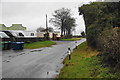
Caravans on Within Lane, Hopton
There is a mibile home settlement here, followed by an industrial estate just further on.
Image: © Bill Boaden
Taken: 28 Dec 2012
0.06 miles
2
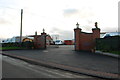
Entrance to a Mobile Home Complex, Hopton
Image: © Mick Malpass
Taken: 12 Nov 2011
0.07 miles
3
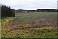
Winter crop near Hopton
At this distance, I couldn't tell what the crop is.
Image: © Bill Boaden
Taken: 28 Dec 2012
0.09 miles
4
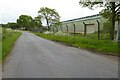
Country road passing a depot
Country road passing a depot near Hopton.
Image: © Philip Halling
Taken: 23 May 2023
0.17 miles
5
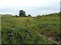
Site of Hopton Heath cutting
The former Great Northern Railway Uttoxeter to Stafford branch line ran through a 20 metre deep rock cutting at this point. It closed in 1951 and the cutting has since been filled in to the level of the surrounding land.
Image: © Alan Murray-Rust
Taken: 16 Aug 2017
0.22 miles