IMAGES TAKEN NEAR TO
Churchill Way, STAFFORD, ST17 9NZ
Introduction
This page details the photographs taken nearby to Churchill Way, ST17 9NZ by members of the Geograph project.
The Geograph project started in 2005 with the aim of publishing, organising and preserving representative images for every square kilometre of Great Britain, Ireland and the Isle of Man.

There are currently over 7.5m images from over14,400 individuals and you can help contribute to the project by visiting https://www.geograph.org.uk
Image Map (Loading...)


Getting Data...Please wait
Leaflet Map data © OpenStreetMap
Images are licensed for reuse under creativecommons.org/licenses/by-sa/2.0
Notes
- Clicking on the map will re-center to the selected point.
- The higher the marker number, the further away the image location is from the centre of the postcode.
Image Listing (8 Images Found)
Images are licensed for reuse under creativecommons.org/licenses/by-sa/2.0
Image
Details
Distance
2

Rising Brook (Stafford) fire station
Rising Brook (Stafford) fire station, Rising Brook, Stafford, Staffordshire
Image: © Kevin Hale
Taken: 29 Jul 2010
0.18 miles
3

Rising Brook (Stafford) fire station
Rising Brook (Stafford) fire station, Rising Brook, Stafford, Staffordshire
Image: © Kevin Hale
Taken: 29 Jul 2010
0.18 miles
7
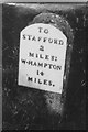
Old Milestone by the A449, Mosspit, Stafford parish
Wolverhampton iron plate by the A449, Mosspit in parish of Stafford (Stafford District), East side of road, has been missing for many years.
Lost since 1940.
Inscription reads:-
TO
STAFFORD
2
MILES.
W-HAMPTON
14
MILES.
Milestone Society National ID: ST_WVST14
Image: © Milestone Society
Taken: Unknown
0.23 miles
8
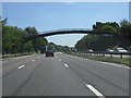
M6 motorway - footbridge near Moss Pit
A rare survivor of the early style of arched footbridge used on the M6. Another example is a few miles north near junction 15. See http://www.geograph.org.uk/photo/1630819 and http://www.geograph.org.uk/photo/414387
Image: © J Whatley
Taken: 16 Jun 2010
0.24 miles