IMAGES TAKEN NEAR TO
Rowley Avenue, STAFFORD, ST17 9AA
Introduction
This page details the photographs taken nearby to Rowley Avenue, ST17 9AA by members of the Geograph project.
The Geograph project started in 2005 with the aim of publishing, organising and preserving representative images for every square kilometre of Great Britain, Ireland and the Isle of Man.

There are currently over 7.5m images from over14,400 individuals and you can help contribute to the project by visiting https://www.geograph.org.uk
Image Map
Images are licensed for reuse under creativecommons.org/licenses/by-sa/2.0
Notes
- Clicking on the map will re-center to the selected point.
- The higher the marker number, the further away the image location is from the centre of the postcode.
Image Listing (65 Images Found)
Images are licensed for reuse under creativecommons.org/licenses/by-sa/2.0
Image
Details
Distance
1
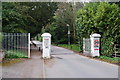
Entrance to the Rowley Park Estate
It is a private road from here on. The sign states that anyone can be turned back unless on genuine business.
Image: © Bill Boaden
Taken: 2 Apr 2011
0.09 miles
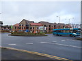
2
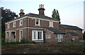
The Hayes, Newport Road, Stafford
A uninterrupted view of The Hayes after several mature trees were removed. The house was built about 1850 and is grade-II listed. For the last 30 years it has been used for commercial purposes but is now being turned back to domestic use.
Image: © Rod Grealish
Taken: 9 Aug 2024
0.10 miles
4
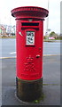
Elizabeth II postbox on Newport Road, Stafford
Postbox No. ST16 26.
See Image] for context.
Image: © JThomas
Taken: 14 Mar 2020
0.13 miles
5

Snowdrops in a garden on Brunswick Terrace
There are about 20 species of Galanthus 0r snowdrop. Galanthus nivalis is the most common and widespread of the snowdrops. The genus Galanthus is from the Greek gála (meaning milk) + ánthos (flower). There are several hundred cultivars of Galanthus nivalis.
Image: © Rod Grealish
Taken: 14 Feb 2004
0.13 miles
7
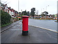
Newport Road (A518), Stafford
Showing position of Postbox No. ST16 26.
See Image] for postbox.
Image: © JThomas
Taken: 14 Mar 2020
0.14 miles
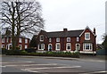
8
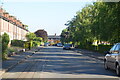
View along Brunswick Terrace Stafford
A view along Brunswick Terrace towards Newport Road. The houses on the left are Grade II listed and were built c1855. The houses on the right, behind the trees, were built in 2007. The absence of parked cars is because the road is about to be resurfaced.
Image: © Rod Grealish
Taken: 5 Jul 2018
0.14 miles
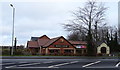
9
Roundabout on the A518, Stafford
New development of flats behind.
Image: © JThomas
Taken: 14 Mar 2020
0.14 miles
10
Houses on North-east side of Brunswick Terrace Stafford
The houses were built in 2007 and were designed to reflect the style of the grade II listed houses on the other side of the road, behind the camera, which were built in 1855 and 1861.
Image: © Rod Grealish
Taken: 20 Dec 2020
0.16 miles