IMAGES TAKEN NEAR TO
Quantico Close, STAFFORD, ST17 4LB
Introduction
This page details the photographs taken nearby to Quantico Close, ST17 4LB by members of the Geograph project.
The Geograph project started in 2005 with the aim of publishing, organising and preserving representative images for every square kilometre of Great Britain, Ireland and the Isle of Man.

There are currently over 7.5m images from over14,400 individuals and you can help contribute to the project by visiting https://www.geograph.org.uk
Image Map
Images are licensed for reuse under creativecommons.org/licenses/by-sa/2.0
Notes
- Clicking on the map will re-center to the selected point.
- The higher the marker number, the further away the image location is from the centre of the postcode.
Image Listing (13 Images Found)
Images are licensed for reuse under creativecommons.org/licenses/by-sa/2.0
Image
Details
Distance
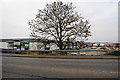
4
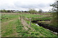
Path by a drainage ditch in Stafford
This is about 1 kilometre from the town centre. If it were not for the drain, the land would be impassable through marshiness. The land forms a green space between the developments alongside the A34 and the A449 to the south of Stafford.
Image: © Bill Boaden
Taken: 2 Apr 2011
0.16 miles
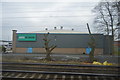
6
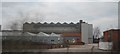
Queens Retail Park
Viewed from the A34 which has to rise quite a lot to get over the railway.
Image: © Bill Boaden
Taken: 2 Apr 2011
0.20 miles
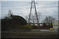
7
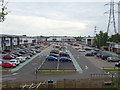
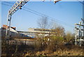
Queens Retail Park, Stafford
View from Queensville Bridge.
Image: © JThomas
Taken: 18 May 2019
0.20 miles