IMAGES TAKEN NEAR TO
Peach Avenue, STAFFORD, ST17 4EQ
Introduction
This page details the photographs taken nearby to Peach Avenue, ST17 4EQ by members of the Geograph project.
The Geograph project started in 2005 with the aim of publishing, organising and preserving representative images for every square kilometre of Great Britain, Ireland and the Isle of Man.

There are currently over 7.5m images from over14,400 individuals and you can help contribute to the project by visiting https://www.geograph.org.uk
Image Map
Images are licensed for reuse under creativecommons.org/licenses/by-sa/2.0
Notes
- Clicking on the map will re-center to the selected point.
- The higher the marker number, the further away the image location is from the centre of the postcode.
Image Listing (6 Images Found)
Images are licensed for reuse under creativecommons.org/licenses/by-sa/2.0
Image
Details
Distance
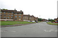
1
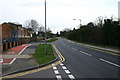
Silkmore Lane, Stafford
Silkmore Lane viewed from the new Co-op store entrance looking in the direction of the A34.
Image: © Stephen Pearce
Taken: 19 Jan 2007
0.12 miles
2
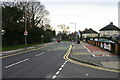
Silkmore Lane, Stafford
Silkmore lane from the entrance to the new Co-op store, looking in the direction of the A449 Stafford to Wolverhapton Road.
Image: © Stephen Pearce
Taken: 19 Jan 2007
0.12 miles
3
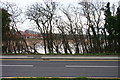
Floodwaters
The floodwaters filling the floodplain of the River Penk viewed from Silkmore Lane, Stafford. The housing in the background is new housing, shown on the current OS map as Works.
Image: © Stephen Pearce
Taken: 19 Jan 2007
0.20 miles
4
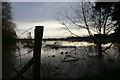
Rising Floodwaters
The floodplain of the River Penk viewed from Silkmore Lane, Stafford, after some heavy rain.
Image: © Stephen Pearce
Taken: 19 Jan 2007
0.20 miles
5
Hawksmoor Road, off Merrivale Road, Stafford
Image: © Mick Malpass
Taken: 27 Jun 2011
0.24 miles
6
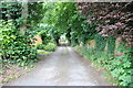
Track to Rickerscote and River Penk Flood Plain
Image: © Mick Malpass
Taken: 27 Jun 2011
0.24 miles