IMAGES TAKEN NEAR TO
Park Street, STAFFORD, ST17 4AL
Introduction
This page details the photographs taken nearby to Park Street, ST17 4AL by members of the Geograph project.
The Geograph project started in 2005 with the aim of publishing, organising and preserving representative images for every square kilometre of Great Britain, Ireland and the Isle of Man.

There are currently over 7.5m images from over14,400 individuals and you can help contribute to the project by visiting https://www.geograph.org.uk
Image Map
Images are licensed for reuse under creativecommons.org/licenses/by-sa/2.0
Notes
- Clicking on the map will re-center to the selected point.
- The higher the marker number, the further away the image location is from the centre of the postcode.
Image Listing (187 Images Found)
Images are licensed for reuse under creativecommons.org/licenses/by-sa/2.0
Image
Details
Distance
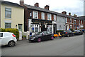
1
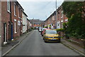
View South along Orchard Street, Stafford
Looking south along Orchard Street to Park Street. The roof of St Austin's Catholic Church can be seen on the skyline
Image: © Rod Grealish
Taken: 15 Jul 2024
0.02 miles
3
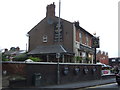
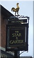
The Star & Garter, Stafford
On Wolverhampton Road.
Image: © JThomas
Taken: 10 Aug 2019
0.03 miles
4
The Star & Garter, Stafford
On Wolverhampton Road.
Image: © JThomas
Taken: 10 Aug 2019
0.03 miles
5
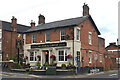
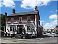
The Star and Garter public house, Wolverhampton Road, Stafford
The Star and Garter public house is on the junction of Wolverhampton Road (A449) and Park Street. It is part of the Dorbiere Pub Group. According to its website the building dates back to the 1820s and over 30 craft gins are served.
Image: © Rod Grealish
Taken: 15 Jul 2024
0.03 miles
7
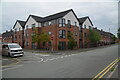
Housing at Junction of Friars Terrace and Park Street, Stafford
This housing development was built in 2015 on the site of Staffordshire County Library and Record (music) Library in Friars Terrace. The housing runs from the extreme left of the image to the extreme right. The library was built in the 1960's(?) as the headquarters of the library service which served those areas of Staffordshire outside of the boroughs for which there was no locally provided library service. Under local government re-organisation in 1974 libraries became a county function and the building became the headquarters of the Staffordshire library service. The housing was built by Stafford and Rural Homes (SARH), a housing association, and the successor to Stafford Borough housing.
Image: © Rod Grealish
Taken: 15 Jul 2024
0.05 miles
9
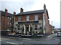
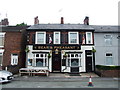
The Bear and Pheasant public house, Friars' Terrace, Stafford
A traditional pub situated in a terrace of houses. OS maps show that the buildings were here by 1889.
Image: © Rod Grealish
Taken: 15 Jul 2024
0.05 miles
