IMAGES TAKEN NEAR TO
Oak Avenue, STAFFORD, ST17 0LX
Introduction
This page details the photographs taken nearby to Oak Avenue, ST17 0LX by members of the Geograph project.
The Geograph project started in 2005 with the aim of publishing, organising and preserving representative images for every square kilometre of Great Britain, Ireland and the Isle of Man.

There are currently over 7.5m images from over14,400 individuals and you can help contribute to the project by visiting https://www.geograph.org.uk
Image Map (Loading...)


Getting Data...Please wait
Leaflet Map data © OpenStreetMap
Images are licensed for reuse under creativecommons.org/licenses/by-sa/2.0
Notes
- Clicking on the map will re-center to the selected point.
- The higher the marker number, the further away the image location is from the centre of the postcode.
Image Listing (17 Images Found)
Images are licensed for reuse under creativecommons.org/licenses/by-sa/2.0
Image
Details
Distance
1
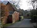
Old Building, Walton On The Hill, Stafford.
Image: © Tim Marshall
Taken: 31 Jan 2009
0.10 miles
2
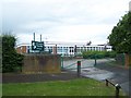
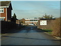
Berkswich C of E Primary School, Walton-On-The-Hill
Image: © Geoff Pick
Taken: 11 Jun 2011
0.10 miles
4
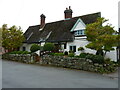
14, The Village
At its heart, this is a small 17th century timber-framed cottage, but has been much altered and extended over the years. Nonetheless it attracted a Grade II listing https://britishlistedbuildings.co.uk/101258837-14-berkswich#.X58DoYj7TIU & https://historicengland.org.uk/listing/the-list/list-entry/1258837 in 1987, as most of the original cottage features remain intact inside the more modern exterior.
Image: © Richard Law
Taken: 18 Oct 2020
0.12 miles
5

The Smithy, Walton on the Hill
As the name implies, the former village smithy, which dates from the 19th century. It's recently been much restored and repaired, and was Grade II listed https://britishlistedbuildings.co.uk/101258838-the-smithy-berkswich#.X58BVIj7TIU & https://historicengland.org.uk/listing/the-list/list-entry/1258838 in 1987.
Image: © Richard Law
Taken: 18 Oct 2020
0.12 miles
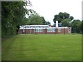
6
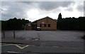
Walton High School
Walton School Old Croft Road
Image: © David Bagshaw
Taken: 28 Nov 2005
0.12 miles
7
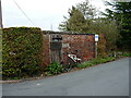
Former village pound, Walton on the Hill
The brick construction is a (probably) early 19th century village pound, which would once have been used to corral stray farm animals. It's now disused.
Image: © Richard Law
Taken: 18 Oct 2020
0.13 miles
8
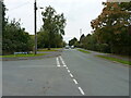
Old Croft Road at the junction with Grosvenor Way
A minor road junction in Walton on the Hill
Image: © Richard Law
Taken: 18 Oct 2020
0.13 miles
9
Berkswich Methodist Church, Walton on the Hill
Situated next to Walton School, Walton on the Hill, Staffs.
Image: © Tim Marshall
Taken: 26 Oct 2008
0.14 miles
10
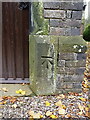
OS benchmark - Walton on the Hill, St Thomas' church
A clear OS cutmark on the porch of the village church, last levelled in 1986 at 109.798m above Ordnance Datum Newlyn. It appears on older maps (1884 onwards) at 360.3 or 360.4 feet above Liverpool datum.
Image: © Richard Law
Taken: 18 Oct 2020
0.16 miles