IMAGES TAKEN NEAR TO
Fairview Way, STAFFORD, ST17 0AU
Introduction
This page details the photographs taken nearby to Fairview Way, ST17 0AU by members of the Geograph project.
The Geograph project started in 2005 with the aim of publishing, organising and preserving representative images for every square kilometre of Great Britain, Ireland and the Isle of Man.

There are currently over 7.5m images from over14,400 individuals and you can help contribute to the project by visiting https://www.geograph.org.uk
Image Map (Loading...)


Getting Data...Please wait
Leaflet Map data © OpenStreetMap
Images are licensed for reuse under creativecommons.org/licenses/by-sa/2.0
Notes
- Clicking on the map will re-center to the selected point.
- The higher the marker number, the further away the image location is from the centre of the postcode.
Image Listing (106 Images Found)
Images are licensed for reuse under creativecommons.org/licenses/by-sa/2.0
Image
Details
Distance
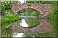
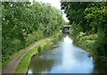
1
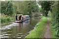
Aphrodite approaching Baswich Bridge
Bridge 100 on the Staffordshire & Worcestershire Canal.
Image: © Bill Boaden
Taken: 5 Oct 2019
0.03 miles
2
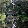
Staffordshire and Worcestershire Canal near Stafford
This is the Staffordshire and Worcestershire Canal near Weeping Cross, Stafford. Ahead is Baswick Bridge, No 100.
On Victorian maps and since, this is listed as Baswich Bridge (near the corresponding Baswich Holy Trinity Church) so the spelling on the bridge plate may just be an error. Even Berkswich would be more appropriate.
Image: © Roger Kidd
Taken: 17 Sep 2019
0.04 miles
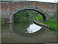
3
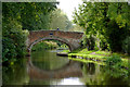
Baswick Bridge near Stafford
Looking south-west, Baswick Bridge (near Baswich!) is No 100 across the Staffordshire and Worcestershire Canal. It is a farmer's accommodation bridge allowing access to the meadows on the Penk/Sow flood plain (off to the right). The fields which were off to the left have long been built over with housing.
On Victorian maps and since, this is listed as Baswich Bridge (near the corresponding Baswich Holy Trinity Church) so the spelling on the bridge plate may just be an error. Even Berkswich would be more appropriate.
Image: © Roger D Kidd
Taken: 6 Oct 2017
0.04 miles
4
Baswick Bridge near Stafford
Looking south-west, Baswick Bridge (near Baswich!) is No 100 across the Staffordshire and Worcestershire Canal. It is a farmer's accommodation bridge allowing access to the meadows on the Penk/Sow flood plain (off to the right). The fields which were off to the left have long been built over with housing.
On Victorian maps and since, this is listed as Baswich Bridge (near the corresponding Baswich Holy Trinity Church) so the spelling on the bridge plate may just be an error. Even Berkswich would be more appropriate.
Image: © Roger D Kidd
Taken: 6 Oct 2017
0.04 miles
5
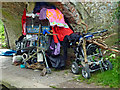
Living rough by the canal near Stafford
Whoever is responsible for this mess has been here for some time. I didn't check what was in the cage.
Baswick Bridge, No 100 over the Staffordshire and Worcestershire Canal.
On Victorian maps and since, this is listed as Baswich Bridge (near the corresponding Baswich Holy Trinity Church) so the spelling on the bridge plate may just be an error. Even Berkswich would be more appropriate.
Image: © Roger Kidd
Taken: 30 Aug 2013
0.04 miles
6

Baswick Bridge south-east of Stafford
Baswick Bridge is No 100 over the Staffordshire and Worcestershire Canal. This was purely a farmer's accommodation bridge, but with the land to the right fully covered with housing estates I am not sure how it is used. Certainly the meadows to the left by the River Penk still need occasional access.
In August 2013, someone was dossing under the bridge and his possessions partly block the towpath!
Image]
On Victorian maps and since, this is listed as Baswich Bridge (near the corresponding Baswich Holy Trinity Church) so the spelling on the bridge plate may just be an error. Even Berkswich would be more appropriate.
Image: © Roger Kidd
Taken: 30 Aug 2013
0.04 miles
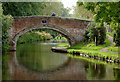
7
Baswick Bridge near Stafford
Looking north towards Great Haywood Junction, Baswick Bridge is No 100 across the Staffordshire and Worcestershire Canal, near Baswich! It was originally a farmer's accommodation bridge, but now functions as a footbridge giving access to and from Fairview Way in the housing estate.
On Victorian maps and since, this is listed as Baswich Bridge (near the corresponding Baswich Holy Trinity Church) so the spelling on the bridge plate may just be an error. Even Berkswich would be more appropriate.
Image: © Roger Kidd
Taken: 17 May 2019
0.04 miles
8
Baswick Bridge south-east of Stafford
Baswick Bridge is No 100 across the Staffordshire and Worcestershire Canal. There is access to Fairview Way off to the left, and meadows by the Deepmore Drain and the River Penk off to the right, though I am unsure of the public status of that.
On Victorian maps and since, this is listed as Baswich Bridge (near the corresponding Baswich Holy Trinity Church) so the spelling on the bridge plate may just be an error. Even Berkswich would be more appropriate.
Image: © Roger Kidd
Taken: 21 Oct 2011
0.04 miles
9
Baswich Bridge south-east of Stafford
Baswich Bridge* is No 100 across the Staffordshire and Worcestershire Canal. It was just an accommodation bridge, but now also carries a public footpath allowing access from the housing estate off to the right. There is also access to the meadows off to the left.
The Way for the Millennium passes along the towpath here. https://www.staffordshire.gov.uk/environment/RightsofWay/distancewalks/ROWPromotedRouteMillennium.aspx#staffordshugborough
* The bridge plate calls this Baswick Bridge, but this may be a BWB error. Maps since Victorian times use the more usual Baswich Bridge.
Image: © Roger Kidd
Taken: 4 Aug 2015
0.04 miles
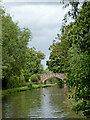
10
Staffordshire and Worcestershire Canal, Baswich
Looking north from Baswich Bridge.
Image: © Alan Murray-Rust
Taken: 16 Aug 2017
0.04 miles