IMAGES TAKEN NEAR TO
Earlswood Road, STOKE-ON-TRENT, ST1 6UF
Introduction
This page details the photographs taken nearby to Earlswood Road, ST1 6UF by members of the Geograph project.
The Geograph project started in 2005 with the aim of publishing, organising and preserving representative images for every square kilometre of Great Britain, Ireland and the Isle of Man.

There are currently over 7.5m images from over14,400 individuals and you can help contribute to the project by visiting https://www.geograph.org.uk
Image Map (Loading...)


Getting Data...Please wait
Leaflet Map data © OpenStreetMap
Images are licensed for reuse under creativecommons.org/licenses/by-sa/2.0
Notes
- Clicking on the map will re-center to the selected point.
- The higher the marker number, the further away the image location is from the centre of the postcode.
Image Listing (43 Images Found)
Images are licensed for reuse under creativecommons.org/licenses/by-sa/2.0
Image
Details
Distance
1
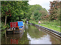
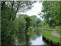
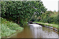
Canal maintenance north-east of Stoke-on-Trent
Looking north as the Caldon Canal meanders towards Milton, Stockton Brook, Endon, Cheddleton and Froghall. The canal passes through a long strip of deciduous woodland which includes the track bed of the disused railway between Caldon Low and Stoke (off to the left), and the slopes down to the River Trent (off to the right).
New metal piling is being installed by the towpath, but for now they've stopped for lunch!
Image: © Roger Kidd
Taken: 12 Sep 2019
0.08 miles
2
Canal maintenance north-east of Stoke-on-Trent
Looking north as the Caldon Canal meanders towards Milton, Stockton Brook, Endon, Cheddleton and Froghall. The canal passes through a long strip of deciduous woodland which includes the track bed of the disused railway between Caldon Low and Stoke (off to the left), and the slopes down to the River Trent (off to the right).
New metal piling is being installed by the towpath, but for now they've stopped for lunch!
Image: © Roger Kidd
Taken: 12 Sep 2019
0.08 miles
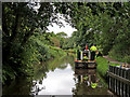
3
Caldon canal east of Birches Head, Stoke-on-Trent
The River Trent meanders northwards through scrub and grass land about fifty metres off to the right. The former railway from Stoke to Leek and Cauldon Low runs through the trees on the left, beyond which is the housing estate at Birches Head.
The Caldon Branch of the Trent and Mersey Canal opened in 1779. It runs eighteen miles from Etruria in Stoke-on-Trent, where it leaves the Trent and Mersey Canal. It terminates at Froghall about five miles south-east of Cheddleton. The canal has seventeen locks and the 69 metre long very low Froghall Tunnel, unusable by many narrowboats. The canal did originally continue through to Uttoxeter, but the section beyond Froghall was closed by the late 1840s, much of its course being filled in to construct a railway.
Image: © Roger D Kidd
Taken: 27 May 2011
0.08 miles
4
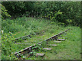
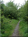
Disused railway north of Bucknall, Stoke-on-Trent
Looking towards Stoke.
This line is soon to be re-opened if the Moorland and City Railways Co succeed in their plans. It was part of the North Staffordshire Railway from Stoke towards Congleton, with a branch near Milton going to Cauldon Low Quarry and Leek. The line closed for freight in 1988
http://www.mcrailways.co.uk/
Image: © Roger D Kidd
Taken: 27 May 2011
0.08 miles
5
Disused railway north of Bucknall, Stoke-on-Trent
Looking towards Stoke.
This line is soon to be re-opened if the Moorland and City Railways Co succeed in their plans. It was part of the North Staffordshire Railway from Stoke towards Congleton, with a branch near Milton going to Cauldon Low Quarry and Leek. The line closed for freight in 1988.
http://www.mcrailways.co.uk/
Image: © Roger D Kidd
Taken: 27 May 2011
0.08 miles
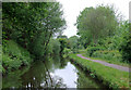
6
Canal maintenance north-east of Stoke-on-Trent
Looking north as the Caldon Canal meanders towards Milton, Stockton Brook, Endon, Cheddleton and Froghall. The canal passes through a long strip of deciduous woodland which includes the track bed of the disused railway between Caldon Low and Stoke (off to the left), and the slopes down to the River Trent (off to the right).
Towpath piling is under way ahead.
Image: © Roger Kidd
Taken: 12 Sep 2019
0.08 miles
7
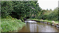
Caldon canal east of Birches Head, Stoke-on-Trent
The River Trent meanders northwards through scrub and grass land about fifty metres off to the right.
The Caldon Branch of the Trent and Mersey Canal opened in 1779. It runs eighteen miles from Etruria in Stoke-on-Trent, where it leaves the Trent and Mersey Canal. It terminates at Froghall about five miles south-east of Cheddleton. The canal has seventeen locks and the 69 metre long very low Froghall Tunnel, unusable by many narrowboats. The canal did originally continue through to Uttoxeter, but the section beyond Froghall was closed by the late 1840s, much of its course being filled in to construct a railway.
Image: © Roger D Kidd
Taken: 27 May 2011
0.09 miles
8
Caldon Canal east of Birches Head, Stoke-on-Trent
Looking north as the Caldon Canal meanders towards Milton, Stockton Brook, Endon, Cheddleton and Froghall. The canal passes through a long strip of deciduous woodland which includes the track bed of the disused railway between Caldon Low and Stoke (off to the left), and the slopes down to the River Trent (off to the right).
Image: © Roger Kidd
Taken: 12 Sep 2019
0.09 miles
9
Canal near Abbey Hulton, Stoke-on-Trent
Looking north as the Caldon Canal meanders towards Milton, Stockton Brook, Endon, Cheddleton and Froghall. The canal passes through a long strip of deciduous woodland which includes the track bed of the disused railway between Caldon Low and Stoke (off to the left), and the slopes down to the River Trent (off to the right).
Image: © Roger Kidd
Taken: 12 Sep 2019
0.09 miles
10
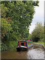
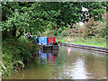
Narrowboat near Abbey Hulton, Stoke-on-Trent
Looking north as the Caldon Canal meanders towards Milton, Stockton Brook, Endon, Cheddleton and Froghall.
The 55 foot long narrowboat 'Pompey Chimes' is a long way from its home on the River Wey. The boat displays the coat of arms of the City of Portsmouth.
Image: © Roger Kidd
Taken: 12 Sep 2019
0.09 miles