IMAGES TAKEN NEAR TO
Riverside, STAFFORD, ST16 9SA
Introduction
This page details the photographs taken nearby to Riverside, ST16 9SA by members of the Geograph project.
The Geograph project started in 2005 with the aim of publishing, organising and preserving representative images for every square kilometre of Great Britain, Ireland and the Isle of Man.

There are currently over 7.5m images from over14,400 individuals and you can help contribute to the project by visiting https://www.geograph.org.uk
Image Map (Loading...)


Getting Data...Please wait
Leaflet Map data © OpenStreetMap
Images are licensed for reuse under creativecommons.org/licenses/by-sa/2.0
Notes
- Clicking on the map will re-center to the selected point.
- The higher the marker number, the further away the image location is from the centre of the postcode.
Image Listing (541 Images Found)
Images are licensed for reuse under creativecommons.org/licenses/by-sa/2.0
Image
Details
Distance
1
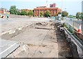
The changing face of Stafford
The Tipping Street car park has been closed and archaeological surveys are being carried out pending the development of a new complex of County Council Buildings. This picture shows the outline of the remains of gardens belonging to houses along the former South Walls.
South Walls lies to the right, the red brick building is the Magistrates Court, Probation Offices and Police Station.
Image: © Simon Huguet
Taken: 19 Aug 2009
0.02 miles
2
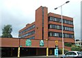
Borough Offices
The Stafford Borough Council offices at the Riverside.
Image: © Simon Huguet
Taken: 4 Jul 2010
0.02 miles
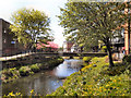
3
Riverway, Stafford
Nearing the end of the Brocton - Stafford cycle route/footpath. Two minutes from an on foot arrival in Stafford, the bulk of the council offices dominate the right hand side of the view. The ducks on the River Sow are uninterested.
Image: © Tim Marshall
Taken: 13 Sep 2012
0.02 miles
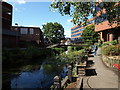
4
River Sow, Stafford
The River Sow, passing through Stafford town centre
Image: © David Dixon
Taken: 12 Apr 2011
0.02 miles
5
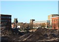
The changing face of Stafford
Looking into the town centre across the piles of hardcore that were once the Riverside Sports Centre. The old town's South Wall ran along the line of the trees and red brick rubble. To the left is the Borough Council Offices, followed left to right by the towers of St Mary's and St Chad's churches, the County Education offices and the Magistrate's Courts. This townscape will not last for long - planning consent has been granted to the County Council for a huge office complex which will fill the middle ground and there are also plans for an apartment complex on the former Riverside site.
Image: © Simon Huguet
Taken: 25 Nov 2008
0.03 miles
6
![The changing face of Stafford [continued]](https://s1.geograph.org.uk/geophotos/01/95/90/1959029_450cf28e_120x120.jpg)
The changing face of Stafford [continued]
The new County Council development rises over South Walls.
Image: © Simon Huguet
Taken: 4 Jul 2010
0.03 miles
7
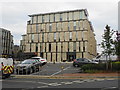
Staffordshire Place
New £38M offices for Staffordshire County Council bringing together staff from various sites around the town and providing a modern library.
Image: © John M
Taken: 20 Oct 2018
0.03 miles
8
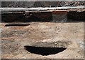
The changing face of Stafford
The Tipping Street car park has been closed and archaeological surveys are being carried out pending the development of a new complex of County Council Buildings. This picture shows what are probably the cellars of houses around Apple Tree Court - one of the courtyards that grew up behind the facades of many C18th and C19th town streets. Each house in such a court would have probably have housed several families or a family and lodgers and were where many of the working class people of the day lived.
The darker earth areas being excavated may be old rubbish pits.
Image: © Simon Huguet
Taken: 19 Aug 2009
0.03 miles
9
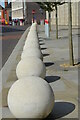
A line of concrete spheres
The spheres line part of South Walls preventing vehicles from entering the pedestrian area and approaching the main office blocks of Staffordshire County Council on the right. The building was purpose-built for the council in 2011 and consists of two separate blocks known as Staffordshire Place.
Image: © Rod Grealish
Taken: 24 Aug 2014
0.03 miles
10
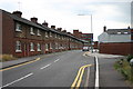
South Walls, Stafford
South Walls in Stafford looking towards the town centre. The old terraced houses on the left are soon to be flattened for retail use. The Riverside (Council) Offices stand over the terraces in the background.
Image: © Stephen Pearce
Taken: 11 Jul 2005
0.03 miles