IMAGES TAKEN NEAR TO
Birkdale Drive, STAFFORD, ST16 3XQ
Introduction
This page details the photographs taken nearby to Birkdale Drive, ST16 3XQ by members of the Geograph project.
The Geograph project started in 2005 with the aim of publishing, organising and preserving representative images for every square kilometre of Great Britain, Ireland and the Isle of Man.

There are currently over 7.5m images from over14,400 individuals and you can help contribute to the project by visiting https://www.geograph.org.uk
Image Map (Loading...)


Getting Data...Please wait
Leaflet Map data © OpenStreetMap
Images are licensed for reuse under creativecommons.org/licenses/by-sa/2.0
Notes
- Clicking on the map will re-center to the selected point.
- The higher the marker number, the further away the image location is from the centre of the postcode.
Image Listing (43 Images Found)
Images are licensed for reuse under creativecommons.org/licenses/by-sa/2.0
Image
Details
Distance
1
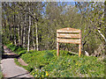
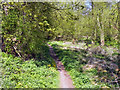
Kingston Pool Covert (South) Local Nature Reserve
The Birkdale Road entrance to the Local Nature Reserve.
Image: © David Dixon
Taken: 12 Apr 2011
0.05 miles
3
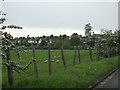
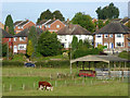
Looking across the fields to the Houses
At the edge of Stafford
Image: © David Bagshaw
Taken: 21 May 2006
0.10 miles
4
Pasture and housing east of Stafford
Seen from the new Two Ways Way bridge, looking north-east. The housing on Kingston Hill is in Tixall Road and Colwich Crescent.
Image: © Roger D Kidd
Taken: 29 Sep 2016
0.10 miles
5
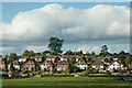
Housing near Kingston Hill, Stafford
A telephoto assisted image, looking north-west across the River Sow flood plain from Baswich Lane at St Thomas Bridge. The housing is about five hundred metres away.
Image: © Roger Kidd
Taken: 16 Oct 2011
0.11 miles
6
Kingston Pool Covert (South) Local Nature Reserve
Image: © David Dixon
Taken: 12 Apr 2011
0.11 miles
7
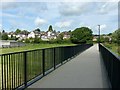
Two Waters Way, Baswich
An elevated foot and cycle way with longer spans over the Rivers Penk and Sow (the Two Waters), creating a brand new pedestrian and cycle link in the eastern part of Stafford. It was opened in 2015.
Image: © Alan Murray-Rust
Taken: 16 Aug 2017
0.12 miles
8
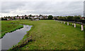
Flood plain pasture east of Stafford
Looking upstream along the River Sow, towards Kingston Hill, this image of the Sow/Penk flood plain was taken from the Two Waters Way footpath (also visible on the right).
Image]
Image: © Roger D Kidd
Taken: 28 Sep 2016
0.12 miles
9
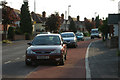
Novel parking
Since when have cycle lanes been car-parks?
Image: © Row17
Taken: 2 Jun 2009
0.12 miles