IMAGES TAKEN NEAR TO
Greengate Walk, STAFFORD, ST16 2HU
Introduction
This page details the photographs taken nearby to Greengate Walk, ST16 2HU by members of the Geograph project.
The Geograph project started in 2005 with the aim of publishing, organising and preserving representative images for every square kilometre of Great Britain, Ireland and the Isle of Man.

There are currently over 7.5m images from over14,400 individuals and you can help contribute to the project by visiting https://www.geograph.org.uk
Image Map (Loading...)


Getting Data...Please wait
Leaflet Map data © OpenStreetMap
Images are licensed for reuse under creativecommons.org/licenses/by-sa/2.0
Notes
- Clicking on the map will re-center to the selected point.
- The higher the marker number, the further away the image location is from the centre of the postcode.
Image Listing (595 Images Found)
Images are licensed for reuse under creativecommons.org/licenses/by-sa/2.0
Image
Details
Distance
1
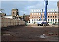
The changing face of Stafford (continued)
17 January 2010 and the archaeologists have finished work and piling is underway on the new County Council development. The machine is parked in what was once the garden of St Chad's vicarage. The ancient church of St Chad's is clearly visible - at least temporarily.
Image: © Simon Huguet
Taken: 17 Jan 2010
0.01 miles
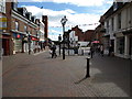
2
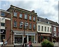
19 and 20 Greengate Street, Stafford
Former mid to late 18th century town houses, now shops. Listed Grade II.
Image: © Alan Murray-Rust
Taken: 23 Aug 2017
0.01 miles
3
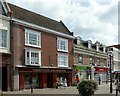
21 ? 23 Greengate Street, Stafford
Former 18th century town houses, now shops. 21, 22 nearer is early 18th century, with modernised early 19th century facade. 23 beyond is slightly later. Both buildings are Listed Grade II.
Image: © Alan Murray-Rust
Taken: 23 Aug 2017
0.01 miles
4
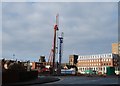
The changing face of Stafford (continued)
17 January 2010 and the archaeologists have finished work and piling is underway on the new County Council development. Looking from the car park by the Borough Council offices on South Walls. The towers of the ancient church of St Chad and the Collegiate church of St Mary are clearly visible - at least temporarily.
Image: © Simon Huguet
Taken: 17 Jan 2010
0.02 miles
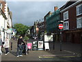
6
Greengate Street, Stafford
Greengate Street, Stafford looking into the town centre.
Image: © Tim Marshall
Taken: 13 Sep 2012
0.02 miles
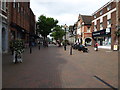
7
Greengate Street, Stafford
Looking towards Mill Street (right) and Bridge Street (straight on).
Image: © Tim Marshall
Taken: 13 Sep 2012
0.02 miles
8
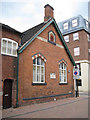
St Chad's Schoolroom, Tipping Street
The inscription between the windows can be viewed at Image
Image: © Robin Stott
Taken: 4 Jul 2011
0.03 miles
9
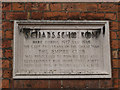
Inscription, St Chad's Schoolroom, Tipping Street
"Here during 1917 and 1918, the last two years of the Great War, the Empire Club was privileged to provide rest and refreshment for more than forty thousand men of His Majesty's forces."
A view of the schoolroom is at Image
Image: © Robin Stott
Taken: 4 Jul 2011
0.03 miles
10
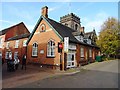
St Chad's Schoolroom
Used as a 'Soldier's Restroom' during the Great War.
Image: © John M
Taken: 28 Oct 2017
0.03 miles