IMAGES TAKEN NEAR TO
North Castle Street, STAFFORD, ST16 2EH
Introduction
This page details the photographs taken nearby to North Castle Street, ST16 2EH by members of the Geograph project.
The Geograph project started in 2005 with the aim of publishing, organising and preserving representative images for every square kilometre of Great Britain, Ireland and the Isle of Man.

There are currently over 7.5m images from over14,400 individuals and you can help contribute to the project by visiting https://www.geograph.org.uk
Image Map
Images are licensed for reuse under creativecommons.org/licenses/by-sa/2.0
Notes
- Clicking on the map will re-center to the selected point.
- The higher the marker number, the further away the image location is from the centre of the postcode.
Image Listing (88 Images Found)
Images are licensed for reuse under creativecommons.org/licenses/by-sa/2.0
Image
Details
Distance
1
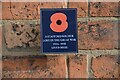
Great War Plaque, North Castle Street, Stafford
This plaque is found all over Stafford marking houses in which a soldier, sailor or airman who died in World War I lived. The plaque would, of course, only be found on houses built before the end of WWI
Image: © Rod Grealish
Taken: 17 Oct 2023
0.02 miles
2
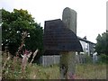
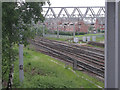
Very rare railway trespass notice still in situ, Stafford.
Damaged but identifiable trespass notice at the site of the former junction between the West Coast Main Line of the London and North Western Railway (later LMS) and the Stafford to Uttoxeter branch line of the Great Northern Railway (later LNER). This branch line was the most westerly point on the GNR system. Also visible is a damaged trespass notice. Could this be the last relic of the London and North Eastern Railway Company still in situ in Stafford 60+ years after that company ceased to exist? Most of these notices were removed long ago and now grace museums and homes throughout the world! This one seems to have received the unsuccessful attention of thieves. There is evidence that a further notice once graced the post too.
Image: © Tim Marshall
Taken: 1 Oct 2008
0.03 miles
4
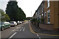
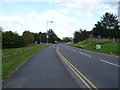
Doxey Road, Castletown, Stafford
This section of Doxey road has been replaced by a new road on the left behind the trees. The residents now enjoy on-street residential parking and less road noise and traffic. The new road is part of the Western Access route around Stafford by-passing the town centre and opening up new land for development.
Image: © Rod Grealish
Taken: 17 Oct 2023
0.04 miles
5
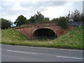
Former junction of Stafford - Uttoxeter Line, GNR
Site of the former junction between the West Coast Main Line of the London and North Western Railway (later LMS) and the Stafford to Uttoxeter branch line of the Great Northern Railway (later LNER). This branch line was the most westerly point on the GNR system. Also visible is a damaged trespass notice. Could this be the last relic of the London and North Eastern Railway Company still in situ in Stafford 60+ years after that company ceased to exist?
Image: © Tim Marshall
Taken: 1 Oct 2008
0.06 miles
8
The West Coast Mainline
The single track leaving the mainline on the left was the route taken by what is now 'The Way of the Millennium'.
Image: © Row17
Taken: 30 May 2008
0.07 miles
9
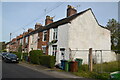
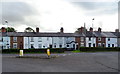
Houses on Castle View, Castletown Stafford
A row of 19th century houses built at different times.
Image: © Rod Grealish
Taken: 17 Oct 2023
0.08 miles
10
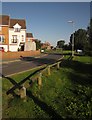
Timberfields Drive, Stafford
Seen from the junction with Doxey Road. The estate is on the edge of the flood plain of the Sow.
Image: © Derek Harper
Taken: 7 Sep 2012
0.08 miles