IMAGES TAKEN NEAR TO
Chapel Street, STAFFORD, ST16 2BX
Introduction
This page details the photographs taken nearby to Chapel Street, ST16 2BX by members of the Geograph project.
The Geograph project started in 2005 with the aim of publishing, organising and preserving representative images for every square kilometre of Great Britain, Ireland and the Isle of Man.

There are currently over 7.5m images from over14,400 individuals and you can help contribute to the project by visiting https://www.geograph.org.uk
Image Map
Images are licensed for reuse under creativecommons.org/licenses/by-sa/2.0
Notes
- Clicking on the map will re-center to the selected point.
- The higher the marker number, the further away the image location is from the centre of the postcode.
Image Listing (502 Images Found)
Images are licensed for reuse under creativecommons.org/licenses/by-sa/2.0
Image
Details
Distance
1
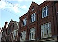
Red brick facades, Crabbery Street
Like many small towns the buildings in Stafford town centre merit closer inspection at first floor level and above, often showing signs of their former glory when they were houses before they became shops. This group of C19th buildings exude a commercial confidence and solidarity.
Image: © Simon Huguet
Taken: 15 Mar 2009
0.01 miles
2
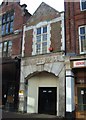
Entrance to the old town market
This is one of the doors to the former St John's indoor market, now moved into the Guildhall complex.
Image: © Simon Huguet
Taken: 15 Mar 2009
0.02 miles
3

Blue plaque, former Methodist Church, Chapel Street, Stafford
See http://www.geograph.org.uk/photo/5506669 for location.
Image: © Alan Murray-Rust
Taken: 16 Aug 2017
0.02 miles
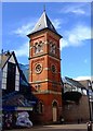
4
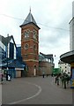
Former Methodist chapel tower, Chapel Street, Stafford
Built in 1863, now incorporated into the modern Stafford Market. A blue plaque on the tower http://www.geograph.org.uk/photo/5506663 tells the story. A fine example of polychrome brickwork.
Image: © Alan Murray-Rust
Taken: 16 Aug 2017
0.02 miles
5
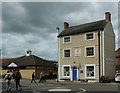
St Bernard's House, Broad Street
Named on the maps at one time as Stafford Catholic Club, St Bernard's House dates from around 1810 and was Grade II listed https://britishlistedbuildings.co.uk/101195375-st-bernards-house-stafford#.YaeujdDP3IU & https://historicengland.org.uk/listing/the-list/list-entry/1195375 in 1971. It appears to be in use now as offices.
Image: © Richard Law
Taken: 4 Nov 2020
0.02 miles
6
St Bernard's House, 23, Broad Street, Stafford
Former Georgian town house, now offices. Built c.1810, Listed Grade II.
Image: © Alan Murray-Rust
Taken: 16 Aug 2017
0.02 miles
7
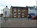
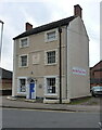
2 Mount Street, Stafford
The part seen here from the street dates to the early 19th century, but it fronts an earlier (17th century) rear wing. Together they were Grade II listed https://britishlistedbuildings.co.uk/101195361-2-mount-street-stafford-forebridge-ward#.YaewHdDP3IU & https://historicengland.org.uk/listing/the-list/list-entry/1195361 in 1971. It appears to be in use as offices at present.
Image: © Richard Law
Taken: 4 Nov 2020
0.02 miles
8
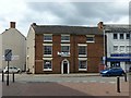
2 Mount Street, Stafford
Former Georgian town house, now offices, in temporary use as a shop. Built c.1810, but with parts of an earlier building at the rear, Listed Grade II.
Image: © Alan Murray-Rust
Taken: 16 Aug 2017
0.03 miles
9
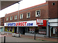
Former WOOLWORTHS shop
The former Woolworths shop in Stafford, July 2009. At least they have found a tenant, but for how long?
Image: © Gordon Cragg
Taken: 16 Jul 2009
0.03 miles
10
Town Market
The tower is all that remains of the former Methodist church that was cleared away as part of the new Guildhall shopping precinct and market complex.
Image: © Simon Huguet
Taken: 12 Apr 2008
0.03 miles