IMAGES TAKEN NEAR TO
Espleys Yard, STAFFORD, ST16 2BS
Introduction
This page details the photographs taken nearby to Espleys Yard, ST16 2BS by members of the Geograph project.
The Geograph project started in 2005 with the aim of publishing, organising and preserving representative images for every square kilometre of Great Britain, Ireland and the Isle of Man.

There are currently over 7.5m images from over14,400 individuals and you can help contribute to the project by visiting https://www.geograph.org.uk
Image Map
Images are licensed for reuse under creativecommons.org/licenses/by-sa/2.0
Notes
- Clicking on the map will re-center to the selected point.
- The higher the marker number, the further away the image location is from the centre of the postcode.
Image Listing (649 Images Found)
Images are licensed for reuse under creativecommons.org/licenses/by-sa/2.0
Image
Details
Distance
1
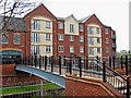
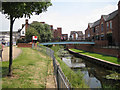
Modern apartments by the River Sow
Both the apartments and the footbridge over the river are fairly new. Next door to these apartments is The Yard, a public house.
Image: © P L Chadwick
Taken: 1 May 2010
0.01 miles
2
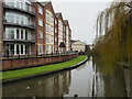
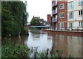
River Sow passing apartment block
The river here is just south of the town centre in Stafford. The apartments are at Riverside Mews.
Image: © Trevor Littlewood
Taken: 23 Dec 2022
0.01 miles
3
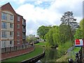
River Sow
The river rises to the south of Newcastle-under-Lyme and is the major river through Stafford. It eventually flows into the River Trent.
Image
Image: © P L Chadwick
Taken: 1 May 2010
0.02 miles
4
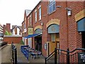
The Yard (1), Unit B, Espley's Yard, Stafford Riverside
The Yard is a modern pub overlooking the River Sow. It is a Smith & Jones pub, which is one of the brands of the Barracuda Group, which was formed in 2000. They now own over 200 managed pubs across England, Scotland and Wales.
Image
Image: © P L Chadwick
Taken: 1 May 2010
0.02 miles
5

The Yard (2), Unit B, Espley's Yard, Stafford Riverside
Another view of this Smith & Jones pub. In the foreground is part of the footbridge across the River Sow from Mill Bank.
Image
Image: © P L Chadwick
Taken: 1 May 2010
0.02 miles
6
River Sow by Mill Bank
Flowing away from the camera past new apartments and shops. This view, straddling a gridline, is the reverse of Image]
Image: © Robin Stott
Taken: 4 Jul 2011
0.02 miles
7
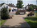
Nervous times.
Although the floods of 5-7 September left Stafford relatively unscathed the residents of this new development right by the River Sow must have been a bit nervous for a while.
Image: © Simon Huguet
Taken: 7 Sep 2008
0.02 miles
9

Landscaped area by River Sow
The river can be glimpsed on the right, but is mainly hidden by the bush and the tree. Photographed from by the two preserved mill wheels of the demolished Town Mill.
Image: © P L Chadwick
Taken: 1 May 2010
0.02 miles
10
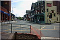
At the South Gate
A view of Bridge Street from the end of Greengate Street at the point where the South Gate on the Town Wall used to be (note the information board just showing in the bottom right corner). Mill Bank goes off to the right and South Walls is to the left.
Image: © Stephen Pearce
Taken: 3 Jun 2007
0.02 miles