
IMAGES TAKEN NEAR TO
Izaak Walton Close, STAFFORD, ST16 1HU
Introduction
This page details the photographs taken nearby to Izaak Walton Close, ST16 1HU by members of the Geograph project.
The Geograph project started in 2005 with the aim of publishing, organising and preserving representative images for every square kilometre of Great Britain, Ireland and the Isle of Man.

There are currently over 7.5m images from over14,400 individuals and you can help contribute to the project by visiting https://www.geograph.org.uk
Image Map
Images are licensed for reuse under creativecommons.org/licenses/by-sa/2.0
Notes
- Clicking on the map will re-center to the selected point.
- The higher the marker number, the further away the image location is from the centre of the postcode.
Image Listing (26 Images Found)
Images are licensed for reuse under creativecommons.org/licenses/by-sa/2.0
Image
Details
Distance
1
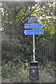
Sign for National Cycle Route 5 on Isabel Trail, Stafford
National Cycle Route 5 runs from Reading to Holyhead. Parts of it remain unspecified. The Isabel Trail is on the track bed of the former Stafford and Uttoxeter Railway between Doxey Road and Beaconside, Stafford which closed in 1975. The trail is named for Isabel, a narrow gauge locomotive built by Bagnalls of Stafford in 1897 and displayed on a plinth outside Stafford railway station from 1963. After restoration she is now in operation on the Amerton Railway
Image: © Rod Grealish
Taken: 17 Oct 2023
0.05 miles
2
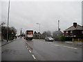
Stone Road, Stafford
Taken on the Stone Road, looking towards Stafford. I was standing beside a grassy area which I am told is Stafford Common, although that name does not appear on the map. It is used for enormous car-boot sales, amongst other things.
Image: © Tricia Neal
Taken: 23 Dec 2013
0.05 miles
4
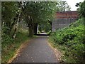
Bridge carrying A5013 over disused railway
Bridge carrying A5013 road over the former GNR Stafford - Uttoxeter line, west of Stafford Common Station, closed to Passengers on 4th December 1939. The line survived for freight and for special servicemens trains until final closure to all regular traffic on 5th March 1951, the last train over the line being an SLS special in March 1957. The line east of Stafford Common Station was lifted in 1959 but the remainder was retained for use by engineers in connection with electrification work on the West Coast Main Line. This stub was finally taken out of use in December 1975.
Image: © Tim Marshall
Taken: 30 Sep 2008
0.12 miles
5
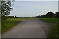
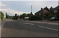
Stafford Common from Stone Road Stafford
The image shows the southernmost part of Stafford Common. The Common is owned by the Stafford Common Land Trustees. It is used for car boot sales, horse and cattle grazing and recreation. Behind the line of trees on the right in a shallow cutting is the route of the former Uttoxeter-Stafford railway line opened in 1867 and closed in sections between 1939 and 1975. The final section between Stafford and the RAF Stafford supply depot was closed in March 1975, There was a station called Stafford Common in the far corner of the Common. Common Road runs at the eastern side of the Common where the industrial buildings can be seen.
Image: © Rod Grealish
Taken: 17 Oct 2023
0.15 miles
6
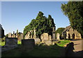
Eccleshall Road Cemetery, Stafford
One of the two chapels shown in Image can be seen on the right.
Image: © Derek Harper
Taken: 7 Sep 2012
0.15 miles
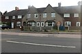
8
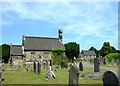
Stafford Cemetery, Eccleshall Road
Stafford Cemetery has two almost identical Chapels of Rest.
Image: © Simon Huguet
Taken: 26 Jul 2008
0.18 miles
9

Stafford Town Cemetery, Eccleshall Road
The C19th cemetery includes this group of War graves from WW2. They are mainly Allied airmen, including some Poles and Canadians, but the graves nearest the camera, to judge by the names appear, to be German. United in death.
There are also a number of graves from WW1, presumably of those who died of wounds after being re-patriated to 'Blighty', but these are scattered across the cemetery rather than grouped together
Image: © Simon Huguet
Taken: 26 Jul 2008
0.18 miles
10
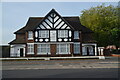
The former pub, The Antelope Inn, on Stone Road, Stafford
The Antelope Inn was closed in 2011. A planning application was approved by Stafford Borough Council in 2014 for a private motorcycle museum on the ground floor with the first floor remaining as private residential accommodation. The building is on the junction of Stone Road and Charles Cotton Street.
Image: © Rod Grealish
Taken: 17 Oct 2023
0.18 miles