IMAGES TAKEN NEAR TO
Cotwalton, STONE, ST15 8TA
Introduction
This page details the photographs taken nearby to ST15 8TA by members of the Geograph project.
The Geograph project started in 2005 with the aim of publishing, organising and preserving representative images for every square kilometre of Great Britain, Ireland and the Isle of Man.

There are currently over 7.5m images from over14,400 individuals and you can help contribute to the project by visiting https://www.geograph.org.uk
Image Map
Images are licensed for reuse under creativecommons.org/licenses/by-sa/2.0
Notes
- Clicking on the map will re-center to the selected point.
- The higher the marker number, the further away the image location is from the centre of the postcode.
Image Listing (5 Images Found)
Images are licensed for reuse under creativecommons.org/licenses/by-sa/2.0
Image
Details
Distance
3
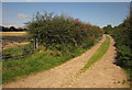
Track near Cotwalton
Rosebay willow-herb sprouts from the hedge at the start of this field access track, seen from the lane between Cotwalton and Hilderstone.
Image: © Derek Harper
Taken: 7 Sep 2012
0.16 miles
4
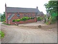
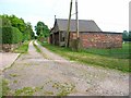
Home Farm at Cotwalton
The buildings on the left look like barn conversions.
Image: © Mick Malpass
Taken: 13 Nov 2011
0.21 miles
5
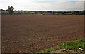
Tilled field, Cotwalton
On a gentle slope leading down to the Cotwalton Dumble, with a tractor working towards the far side. Three isolated trees have been allowed to remain in this arable field.
Image: © Derek Harper
Taken: 7 Sep 2012
0.23 miles